With the New Year well underway, I wanted to take a look and review the advances and advantages of current imaging technology as it relates to creating surfaces from LIDAR and Photogrammetry.
It appears that the more things change, the more they stay the same. Several parts of this world have made great strides while many remain slow to progress.
Drones
UAV platforms are cool, that is unless you have $38,000.00 in the air and it’s not responding to your request to come home. We need this device to do one thing; move a sensor in a predetermined pattern and image when requested and return safely for another use.
Prospective buyers have become focused on flight times, but the real number I always want to know is coverage and quality. A great camera with a proper lens can go high, fly for a short time, and get the accuracy we are after. Once you know all the variables, the questions you ask will change.
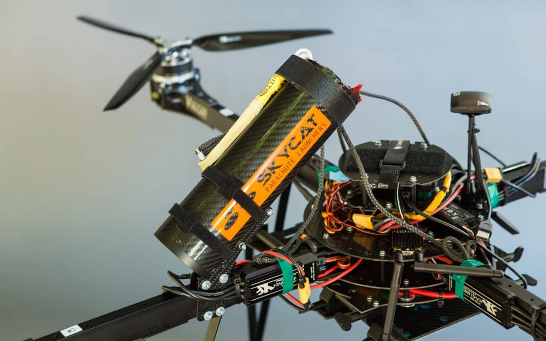
Multirotors have idled in regard to advancement. Good motors, precision GPS, and bigger more efficient batteries have allowed good flight times and safe operation. We use parachutes with our copters and feel comfortable sending them up.
Fixed-wing platforms are split into two distinct camps, hand and wheel launch. The small, quick wings cannot carry good cameras and data quality suffers. The larger platforms need wheels and smooth ground but offer the benefit of carrying a larger sensor for better images. There is crossover in these types including hand launch/belly or parachute landing; the blurred line is offering some possibilities.
I am hoping this next platform gets proven soon, I like where it is going. The VTOL (Vertical Take-off and Landing) plane holds promise. Lift like a copter then fly high and fast with a big camera for a long time. Like any other platform, power is always the issue, to remedy this, some makers are putting gas engines to be used as thrust motors and even generators. I think we will have something worthy by year-end.
Imaging
At this moment, the best solution for aerial topography is a full-frame sensor camera and a good lens. We can obtain good accuracy on a consistent basis. There are some improvements on the horizon that will help things.
When a drone flight is not possible due to regulatory restrictions, our trade partner Doug Andruik at Syn-Geo created a two-camera pod he puts on the strut of a Cessna and effectively does close-range photogrammetry with a full-scale aircraft. A great solution for large acreage or no drone zones.
We are all waiting until LIDAR becomes effective for use on a UAV. Several versions are out with fair accuracies and high price tags. Development is happening daily because of the great potential of the application. I’ll look at these and report as they become available.
Improving Accuracy
One of the best things to come along for improved close-range photogrammetry is precision GPS. The Applanix chips (Trimble) have made geo-referencing images more accurate and easier. When an image is correctly geo-tagged, post-processing is quicker and the resulting 3D information is more accurate. Combine this exacting geo-tagging and good images and accuracy get much better. This makes our fieldwork more efficient and the results in the office better. In my opinion, this is the go-to solution; for now.
Related Article: The Mechanics of GPS Surveying: Methods and Applications
Processing
Pix 4D is still the easiest post-processing software, my issue is the same data set run multiple times yields different results and residuals. As with any processing of imaging data, check to many ground control points to verify accuracy. UAS Master from Trimble is a robust application with the ability to fully incorporate precision GPS orientation from the Applanix chip. I use the software on a regular basis but am hesitant about training users. When you know how all the aspects of the program interface you can do some great things. When first learning post-processing, there are too many variables in the software to “just click a few icons” and get a result like in other applications. That Power can be a pain to use sometimes. Rumors are that there will be some easier workflows coming in future versions, I’ll keep you updated.
Contact TOPS for Accurate LIDAR and Photogrammetry Data
Right now the best way to get reliable, consistent data is to fly a full-frame mirrorless camera with a high-quality lens using a copter with an Applanix chip and post-process in the software of your choice.
Always collect a TON of control/checkpoints so you know how good the results actually are. We earn our money back in the office slowly going over data, cleaning up the point cloud modeling, and shipping the client a good surface.
Whether it’s for urban planning, environmental assessments, or infrastructure projects, TOPS photogrammetry services have proven to be an indispensable tool for professionals. Embracing such cutting-edge technologies ensures that we remain at the forefront of geospatial innovations, harnessing the best of what modern imaging can offer.