CUT AND FILL MAPPING
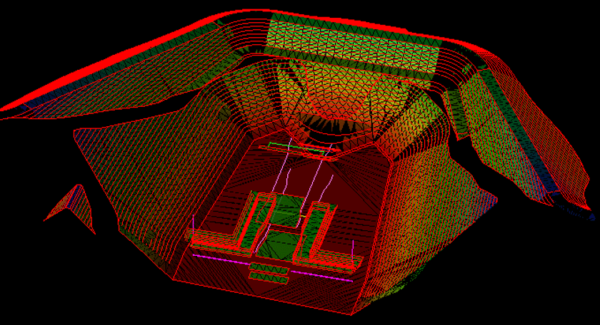
Cut and fill mapping visually represents the excavation and placement of soil and other materials. These maps aid in determining the amount of earth that must be added or removed to create specific grades and contours before building on a job site.
Engineers create cut and fill maps starting with a model of the original site. They analyze the conditions to determine the volume of earth they must move so they can plan for excavation and backfilling.
This mapping method ensures efficiency and accurate earthwork. Engineers optimize their resource use by creating cut and fill maps, reducing unnecessary work and minimizing a job’s time and cost. At Take-off Professionals, our team has extensive cut and fill mapping expertise — we’ll create maps to aid you in preparing earthworks.
TOPS Cut and Fill Modeling Services
At TOPS, our professional team specializes in creating models that show where to add and remove dirt or stone to create the desired surface for building or other tasks. Once we make these models, your teams can use them to guide bulldozers and excavators in removing land. Dump trucks transport the material to other job site areas for filling, and compactors compress the earth, creating a stable surface.
Cut and fill modeling aims to handle earth logically, allowing your teams to avoid bringing in or shipping out soil. Detailed mapping enables you to avoid costly rework and utilize labor and dirt most effectively during excavation and embankment.
This modeling service has applications across various sectors, including:
- Construction: Determine where to add and remove earth to create a smooth and stable building surface.
- Civil engineering: Get the information to prepare a job site for building facilities and water and sewage systems.
- Transportation: Cut and fill maps allow for the construction of roads, railways, canals and other structures that transport people and goods.
- Mining: Detailed maps can help mining operations determine the most effective way to remove dirt and other materials.
Call us at 623-323-8441 to speak directly with a member of our team.
Request A Free Quote
The Details of Cut and Fill Data
Cut and fill data allows machinery and people to work more efficiently by providing an accurate source of information your teams can use to guide your earthworks processes. The data is generated by comparing existing site specifications to the desired result. These comparisons yield two values:
- Cut: This measurement refers to the earth removed from an area or excavated.
- Fill: This value demonstrates the earth brought into an area to form embankments.
Cut and fill data analysis serves a vital purpose in site modeling processes. Engineers use survey data to create 2D or 3D models. 2D models show the values of earth to be removed or added with negative and positive numbers. 3D models lay a representation of the desired terrain over the existing landscape to identify cut and fill areas. No matter the modeling method, model analysis shows where to cut and fill.
Cut and Fill Data Modeling Procedures
The process of cut and fill data modeling takes several steps, bringing you from the original planning stages to the final model. The procedures involved are:
Assessment and Planning
Your processes may change depending on the models you wish to create. During the planning stages, you can determine the type of model you need and the data collection methods you will use to make it.
Data Collection
Data collectors use several tools and methods to create maps of the existing landscape. You may use drone surveys to capture pictures and take land measurements. Global positioning systems (GPS) and global navigation satellite systems (GNSS) are valuable tools for getting site measurements.
Data Analysis
After mapping out the existing conditions, you can use several calculation methods to determine cut and fill values. Automated techniques like the triangular prism method are the fastest way to find these values.
Model Creation
The last step in the mapping process is using the values gathered during data analysis to create a precise model showing where excavation or embankment must occur. The model serves as a guide throughout site preparation to ensure better outcomes.
Why Use Cut and Fill Modeling?
Cut and fill modeling provides the information needed to streamline development projects and tasks involving moving dirt or other materials. It has applications across many industries, from building on a commercial site to preparing land for infrastructure like bridges and sewers. Even mining operations can use this modeling practice to improve excavations.
Another benefit of cut and fill modeling is improved efficiency regarding time and resources. Moving land incurs high costs due to equipment and labor spending. Accurate models allow you to use your machines and people to their highest potential and get the greatest value from your investment.
Detailed data and modeling also enable enhanced decision-making. Your team will have all the necessary information to make informed choices about managing your time and resources for better outcomes.
Benefits of Working With TOPS
Our team understands the value of data and modeling for your operation, which is why we bring expert knowledge through years of experience to enhance project takeoffs. Here are a few reasons to work with us:
- Experience: Our company began providing technology-enabled solutions for clients in 1988. We have extensive expertise in offering data modeling.
- Technology: Beyond the standard modeling software, we also have a proprietary platform that provides a comprehensive work order system.
- Coverage: Our engineers work across three time zones to offer modeling solutions during your workday.
- Track record: We have successfully created many detailed models for clients throughout our decades in business, including cut and fill models.
- Management: We act as your in-house staff, delivering fast and precise models that meet your project scopes.
Discuss Our Services
Cut and fill modeling provides detailed information to show where you need to remove or add dirt and other materials to create a surface for the building. When you go into projects with this knowledge, you can work more efficiently with less time and money invested.
With years of experience and expert cut and fill technology, TOPS brings everything your organization needs for modeling services. Reach out to our team online to discuss your project and learn more about how we can help.