POINT CLOUD MODELING
We turn raw point cloud data into 3D models in your preferred format for streamlined utilization around your job site.
Transform Point Cloud Data to 3D Models with Expert Precision
At TOPS, we specialize in transforming raw point cloud data into accurate 3D models. Whether you need to convert a 3D scan point cloud or a LiDAR point cloud to a 3D model, our point cloud modeling services ensure precision and efficiency for your projects.
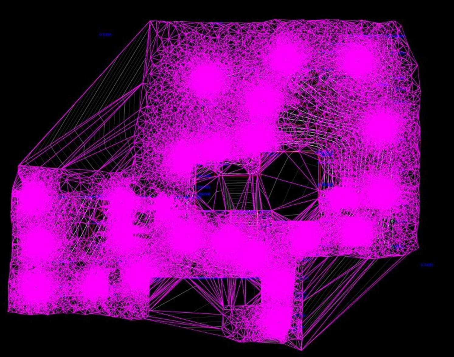
Our point cloud modeling services encompass collecting data points around your job site and compiling them into a mesh form. This mesh fills the spaces between the data points to form a solid, realistic surface that matches your site. Users can export the data to computer-aided design (CAD) programs to create 3D models.
Point cloud modeling suits various applications, including modeling pre-job topographies, progress take-off and as-builts. Our personalized point cloud processing services match your job, efficiently providing models in your preferred formats so you can complete the work.
Call us at 623-323-8441 to speak directly with a member of our team.
Request A Free Quote
LiDAR Point Cloud to 3D Model Solutions for Your Projects
Elevate your construction and earthmoving projects with our specialized Point Cloud Modeling Services. We transform raw point cloud data into actionable models, offering tailored solutions for enhanced precision and efficiency. Our services include:
Point Cloud to Mesh
Use point cloud data to create high-detail mesh models for visualization and analysis.
Point Cloud to CAD
Convert point cloud data into highly accurate CAD models for design and drafting.

LiDAR Data Models
Leverage LiDAR technology to generate precise 3D models for terrain mapping, infrastructure, and more.
What our clients say
Comprehensive Point Cloud Modeling Services for 3D Model Creation
Point cloud data is a collection of small data points with x, y and z coordinates that indicate where the points lie in space. These dots connect to create 3D structures of areas like engineering work sites — the more points collected, the more detailed the final representation of the terrain.
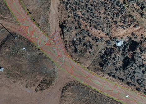
Point cloud data collection begins with site surveying. Surveyors use technology like laser scanners or cameras connected to drones or airplanes to record data points. The first method of laser scanning point cloud services is remote sensing, where drones use pulsed infrared lasers to measure distances and collect data. The second method is surface reconstruction, which involves using a drone camera to capture pictures from various angles and overlapping them to create a point cloud.
Once collected, the point cloud data is uploaded to cloud modeling software and modified as needed for the best accuracy. The points must be uploaded to a CAD or building information modeling (BIM) system to create a 3D format.
Point cloud data serves a vital role in creating precise, high-resolution models. Land surveyors rely on this service to accurately represent landforms that would otherwise require a high level of effort, even for a smaller project. Point cloud data creates models for many uses, including civil construction, commercial sites and residential properties.
Initial Assessment and Planning
Point-cloud modeling begins with initial assessment and planning on your job site. During this stage, you may study maps and other resources to collect information about the building site. Information may include vegetation, soils, existing infrastructure and the geography of surrounding areas.
This information gives you a background to aid your decision-making throughout a project. Once you have some basic information, you can move to point cloud data collection. You must decide which collection method to use and how to analyze the information once collected. Your best choice is to turn to our professional team at TOPS.
Point Cloud Data Collection
After initial assessments and planning, point cloud data collection can begin. The process uses remote sensing or surface reconstruction. Remote sensing involves lasers mounted to drones, while surface reconstruction uses cameras to capture information about a site.
Site surveyors fly drones or airplanes above the construction site to collect the data. The collected point cloud data is stored in a file format like PTS, XYZ, E57, LAS, PTX or PLY. Some of these file formats are universal and work with various point cloud analysis software.
Point Cloud Data Analysis
Once site surveyors collect point cloud data, engineers and 3D techs use software programs like Autodesk AutoCAD, ARES Commander, Trimble SketchUp or Autodesk Revit for point cloud data processing. They transform it from a collection of points to a point cloud. The solution chosen may depend on the format of the data stored and the model you wish to create.
Data analysis involves merging several individual datasets since point cloud scans overlap angles and mapped areas. When engineers combine these datasets, they create one accurate point cloud.
Point Cloud Model Creation
Once engineers generate and refine point cloud data, they can create a CAD or BIM, depending on your preferred format. The 3D model provides detailed information about the site’s terrain, elevation changes, vegetation and other features. This data serves various purposes, including everything from machine control to project tracking.
Ready to discuss your project?
Converting Raw Data to Actionable 3D Models
People often ask what we need to get started on data prep for a project. The process is simple. We just need 3 things to get your data prep job started:
Step 1: PDF Plans
The first thing we need is the civil PDF plan set. This is the heart of the project and should contain all the information needed to build a detailed model or takeoff. Plans should show existing conditions, proposed layout, grading, and utilities, as well as demolition, erosion control, and more. Plans typically come in two formats: vector and raster. Vector PDFs are directly exported from the CAD files and have infinite scalability and sharp quality. Raster PDFs usually result from scanned pages and become pixelated or blurry when zoomed in. Vector plans are always preferred, but we can work with either.

Step 2: CAD Files
The next thing we need is the civil CAD drawings. CAD is compared to the PDF plans to ensure all project data matches and is up to date. We can work with almost any common file format, including the industry-standard AutoCAD .DXF and .DWG, as well as numerous proprietary formats like: PRO, TTM, TIN, DGN, GC3, TP3, TN3, and LN3. Some projects can be completed without CAD, but utilizing these files helps ensure the lowest possible cost and highest quality results.

Step 3: Project Details
Let us know how you want your project built. We can customize any job to your specific needs. You can follow the link on our website to fill out a data prep work order, or email us directly. Just provide the details for your scope of work. No matter what you want or need, we can build it!
We try to make the process as smooth as possible. If you need help or have any questions, just call, email, or click the link to contact us. We are here to help.
Why Choose Our Point Cloud Services
Come to TOPS for a knowledgeable and experienced team of engineers, surveyors and 3D technicians who can use advanced point cloud techniques to prepare 3D models with your point cloud data. We have worked in data preparation since 1988, meaning we lend a depth of expertise to your projects. Our team produces almost 100 machine control models each year, and we rely on full-time employees rather than subcontractors. By trusting every job to our in-house professionals, we can ensure consistent, high-quality work for clients.
Beyond our team’s expertise and experience, we utilize cutting-edge technology to ensure high-quality work. TOPS invests in modeling programs to transform your point cloud data into usable 3D models for various applications. We have created a comprehensive work order system where you can add files, notes and other important project information. The system uses email automation to update you on progress for easier planning.
Learn More About Our Approach →
Efficiency
Point cloud modeling uses a fast site surveying process, using aircraft to collect data rather than requiring people to walk the site. Drones or airplanes can collect data from an expansive area in much less time than a surveying team. Once the data is collected, photogrammetry platforms automatically triangulate points, saving you hours spent manipulating the data. You’ll have access to the project details in less time, allowing you to start work faster and complete projects in less time.
Precision
Airplane- or drone-based point collection methods can yield results that are accurate within centimeters. They use a range of technologies like drones that collect data with photos and use technologies like real-time kinematic (RTK) geotags to record landscapes accurately.
Applications
Point cloud modeling serves various functions, including 3D model reconstruction, machine control, progress tracking, building safety management and geometry quality inspection. Businesses across many construction projects can use this technology to improve their processes throughout every stage of the construction project, from the initial mapping through ongoing project updates.
Savings
The straightforward data collection process means you spend less on manual site surveying, which often requires several workers and hours of labor. Since point clouds create precise models, you can establish more effective budgets with lower chances of exceeding your limits. You’ll have more accurate data, which reduces the possibility you’ll run into unexpected expenses.
Decision-Making
Point cloud modeling gives your operation access to detailed data and models about your building site. You can use this information in the project’s planning stages to inform your processes. For example, factors like elevation may impact which machines are most suitable for site preparation or the specifications of the structure you build.
Contact Take-Off Professionals to Explore Point Cloud Modeling Services
Point cloud modeling transforms data points collected through drone or airplane surveys into detailed and precise 3D models for machine control and other construction applications. At TOPS, our team stands out regarding point cloud modeling due to our extensive experience and professional technology.
Reach out to our team to discuss point cloud modeling services in more detail or to inquire about the availability of our services for your project.