AERIAL PHOTOGRAMMETRY SERVICES
Photogrammetry mapping to deliver superior civil engineering services.
Enhancing Construction Accuracy with Integrated Photogrammetry Mapping Services
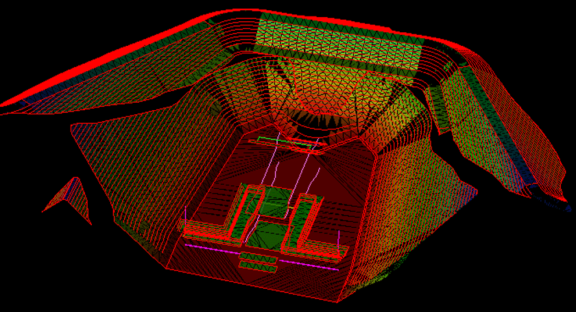
Before your team can launch any construction project, it’s pivotal to acquire an accurate 3D surface model. The integration of photogrammetry mapping can significantly refine the accuracy of these models, aiding not only in layout decisions but also in guiding GPS machine control systems to achieve an outcome that mirrors the engineer’s specifications.
Get Your Free Photogrammetry Model Estimate →
Elevating Construction Workflow with Advanced Photogrammetry Techniques
Utilizing 3D surface models with precise photogrammetry mapping techniques allows your team to work more swiftly, minimizes errors, and ensures the project is done correctly from the outset. For the fullest benefit from a 3D model, photogrammetry services are essential; they must capture every inch of the project site and duplicate the terrane contours with utmost accuracy. Among the various techniques for compiling data for a 3D model, the quickest and most accurate is often through photogrammetry services.
Photogrammetry utilizes photographic analysis to gauge the coordinates of surface points from several perspectives. Aerial photogrammetry mapping is particularly advantageous as drones capture high elevational images, enabling extensive data extraction. The drones’ capability to cover the entire jobsite with limited restrictions positions aerial photogrammetry services as an optimal method for obtaining comprehensive data about the ground, pivotal for both the pre-construction and active construction phases.
Learn More About Photogrammetry →
Your Partner in Precision with Expert Photogrammetry Mapping Services
At Take-Off Professionals (TOPS), we have a dedicated team of engineering and surveying specialists with deep expertise in applying photogrammetry mapping to deliver superior civil engineering photogrammetry services. Our proficiency in creating 3D models from photogrammetry data is complemented by our broad spectrum of precision photogrammetry services.
Request A Free Quote
Photogrammetry Capabilities

TOPS prides itself on a dedication to construction data processing through high-quality photogrammetry services. We manage all forms of data with a strong emphasis on drone photogrammetry mapping. Our photogrammetry services translate aerial data into insightful information that tackles various project challenges.
Expert Photogrammetry Services: Mapping, Modeling, and Custom Solutions
Our extensive list of photogrammetry services covers:
- Precise mapping of drone data point surfaces using state-of-the-art photogrammetry mapping tools.
- Generation of highly accurate topographical files through advanced photogrammetry services.
- Customization of photogrammetry mapping solutions to cater to the unique demands of clients.
Utilize the comprehensive photogrammetry services and surface models we develop for critical tasks such as machine control, layout design, monitoring weekly production, managing billings, and addressing change orders. Beyond these applications, the timelapse imagery produced through our aerial photogrammetry mapping can serve as a powerful marketing tool once construction is completed.
INDUSTRIES SERVED BY AERIAL PHOTOGRAMMETRY
Aerial photogrammetry enables professionals in various industries to make clear, informed decisions quickly and efficiently. It provides accurate, detailed information about an area so you can keep projects moving forward on time and within budget. A few industries that benefit from aerial photogrammetry services include:
- Land surveying: Photogrammetry data provides essential information to help surveyors determine project planning details, from safety measures to possible results. Surveyors can analyze terrain and other area features to assist architects, construction crews, building planners and government record keepers.
- Engineering: Engineers in the project planning and design phases can use photogrammetry data to evaluate project sites, create perspective images and compose 3D renderings of the terrain. Photogrammetry can produce images that enable you to preview ideas, analyze current progress or predict project results.
- Construction: 3D models generated from photogrammetry data allow engineers and contractors to plan construction work sites according to project goals and needs specific to the area. Photogrammetry data can also help you track progress and compare as-built to as-designed plans.
- Mining: You can use photogrammetry to maximize your resources and improve productivity in mining operations. It allows you to measure distances, document terrain, evaluate stockpile volumes and manage other essential processes.
Why We Are The Right Partner
Photogrammetry is a useful tool for surface modeling of construction sites. If you’ve decided to use this technology, you need to ensure you’re getting the most out of your investment.
TOPS is a company exclusively dedicated to data. Our photogrammetry consultants can provide data point modeling quickly, so your team can get to work faster. Our full-time consultants have industry experience and software knowledge that allows them to produce models with high accuracy using data from many collection methods, including aerial photogrammetry.
