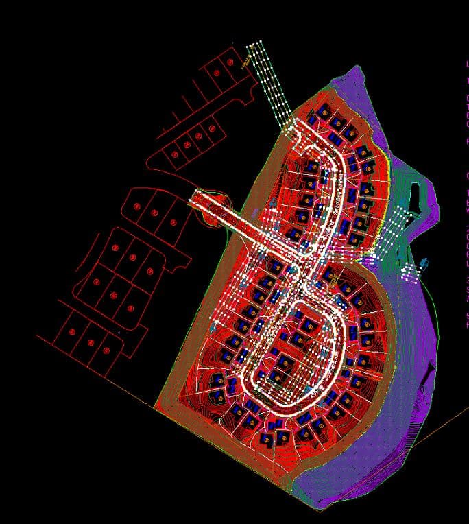
GPS MACHINE CONTROL MODELING
Our team at Take-Off Professionals provides comprehensive GPS modeling and 3D machine control modeling services for all your earthmoving needs. From transforming CAD files to creating precise machine control models and converting paper plans, we ensure your projects are equipped with the tools they need to succeed.
3D and GPS Machine Control Modeling Services
The benefits of machine control modeling systems are what make this breakthrough in earthwork machinery so popular. When carried out correctly — in conjunction with high-quality 3D machine control models — it typically provides the following advantages:
- Increases heavy-duty machine efficiency and productivity.
- Decreases operating expenses such as fuel, repair and maintenance costs.
- Reduces raw materials costs by using them more effectively.
- Lowers surveying costs by eliminating ongoing grade checking.
- Reduces labor costs by increasing individual worker efficiency.
Of course, for any machine control systems project to be successful, the 3D machine control model it’s working off must be accurate and complete. That’s why more and more construction companies are turning to 3D machine control modeling services — like those we provide at TOPS — to bid on, accept and complete more projects with confidence and proficiency.
Call us at 623-323-8441 to speak directly with a member of our team.
Request A Free Quote
The Role of GPS Machine Control in Modern Construction
While the productivity of construction sites was once largely dependent on surveyed stakes and skilled equipment operators, the evolution to GPS machine control systems is forging a new standard for worksite efficiency. GPS machine control consists of instruments that provide machine operators with data on equipment positioning, like bucket and blade positioning and desired grades. Common devices include lasers, sonic equipment, total stations, and particularly advanced 3D machine control technology.
Machine control models are driven by signals from GPS modeling and GNSS, which are similar to those used in consumer devices but tailored for construction operations. Technology in machine control modeling utilizes on-site base stations to contrast signal data, ensuring equipment operates in tandem with the prepared 3D model machine control plans for precise grading.
Enhanced precision from GPS machine control modeling and base stations allows in-field machines to execute tasks at exact coordinates efficiently, minimizing manual stake placements, and saving valuable resources.
Ready to discuss your project?
Applications of GPS Modeling in Heavy Machinery Operation
Sensor technology has paralleled advances in vehicle safety, and similarly, GPS modeling technology has ushered in marked improvements across a range of heavy machinery. The adoption of 3D model machine control is on track to become an industry norm, with numerous manufacturers pre-wiring equipment for this technology.
Applications of 3D machine control modeling include:
Paving:
Utilizing machine control models for automated steering and planning enhances precision in paving procedures.
Dozing:
Implementing 3D machine control modeling augments site safety and enables precise dozing, grading, and scraping.
Excavating:
Machine control modeling services support excavators in maintaining correct positional relations for consistent digging accuracy.
Delivering Precision with In-House Expertise at TOPS
Three Simple Steps to Begin Your Project
People often ask what we need to get started on data prep for a project. The process is simple. We just need 3 things to get your data prep job started:

Step 1: PDF Plans
The first thing we need is the civil PDF plan set. This is the heart of the project and should contain all the information needed to build a detailed model or takeoff. Plans should show existing conditions, proposed layout, grading, and utilities, as well as demolition, erosion control, and more. Plans typically come in two formats: vector and raster. Vector PDFs are directly exported from the CAD files and have infinite scalability and sharp quality. Raster PDFs usually result from scanned pages and become pixelated or blurry when zoomed in. Vector plans are always preferred, but we can work with either.

Step 2: CAD Files
The next thing we need is the civil CAD drawings. CAD is compared to the PDF plans to ensure all project data matches and is up to date. We can work with almost any common file format, including the industry-standard AutoCAD .DXF and .DWG, as well as numerous proprietary formats like: PRO, TTM, TIN, DGN, GC3, TP3, TN3, and LN3. Some projects can be completed without CAD, but utilizing these files helps ensure the lowest possible cost and highest quality results.

Step 3: Project Details
Let us know how you want your project built. We can customize any job to your specific needs. You can follow the link on our website to fill out a data prep work order, or email us directly. Just provide the details for your scope of work. No matter what you want or need, we can build it!
We try to make the process as smooth as possible. If you need help or have any questions, just call, email, or click the link to contact us. We are here to help.
TAKE OFF PROFESSIONALS ARE THE EXPERTS OF ALL THINGS DATA
We have no association with any manufacturer or system type but provide 3D models for all manufacturers
The TOPS Advantage in GPS Machine Control Modeling
With over two decades of expertise in delivering GPS machine control modeling, our commitment to accuracy and detail is evident in our strong performance record. Annually creating approximately 1,000 high-quality machine control models, we strive for exceptional turnaround times and unwavering client support.
Beyond our skillful team and proven success in 3D model machine control, we strive to make your experience seamless. Our custom platform, developed for secure and straightforward client data submissions, underscores that working with TOPS is efficient, enabling you to continue focusing on your business while we expertly handle your GPS machine control modeling needs.
FREQUENTLY ASKED QUESTIONS
What is GPS machine control modeling?
GPS machine control modeling uses 3D design data and GPS technology to guide heavy machinery in construction projects. This allows for precise grading, excavation, and paving, ensuring projects are completed accurately and efficiently. Takeoff Pros specializes in creating these highly accurate 3D models for optimal machine performance.
What's the difference between GPS machine control and traditional surveying?
Traditional surveying relies on manual measurements and staking, which is time-consuming and prone to errors. GPS machine control automates the process, using real-time GPS data to guide equipment. This increases accuracy, reduces rework, and accelerates project timelines. Takeoff Pros delivers models which maximize these benefits.
What applications does GPS machine control work best for?
GPS machine control excels in large-scale earthmoving projects like road construction, site development, and mining operations. Its precision and efficiency are particularly valuable in projects with complex designs or tight tolerances. Takeoff Pros provides expert modeling services across a wide range of these applications.
What are the main benefits of 3D machine control modeling?
The key benefits include improved accuracy, reduced material waste, increased productivity, and enhanced safety. 3D modeling allows for better visualization and planning, minimizing errors and optimizing machine performance. Takeoff Pros helps clients leverage these advantages for successful project outcomes.
What causes project delays in construction, and how does GPS machine control help prevent them?
Common causes of delay include rework due to errors, material shortages, and inefficient workflows. GPS machine control minimizes these issues by ensuring accuracy, optimizing material usage, and streamlining operations. Takeoff Pros helps prevent delays with precise and reliable 3D models tailored to project needs.