Digital Surface Models
Generate sophisticated digital surface models (DSMs) to understand a region’s topographical characteristics in-depth.
Unlock In-Depth Insights with Advanced Digital Surface Modeling Services
The professionals at TOPS are dedicated to providing precision mapping services to deliver crucial data that drive efficiency and success. Our matchless combination of expertise and technology ensures our team has the skills and capabilities to help you construct high-quality models.
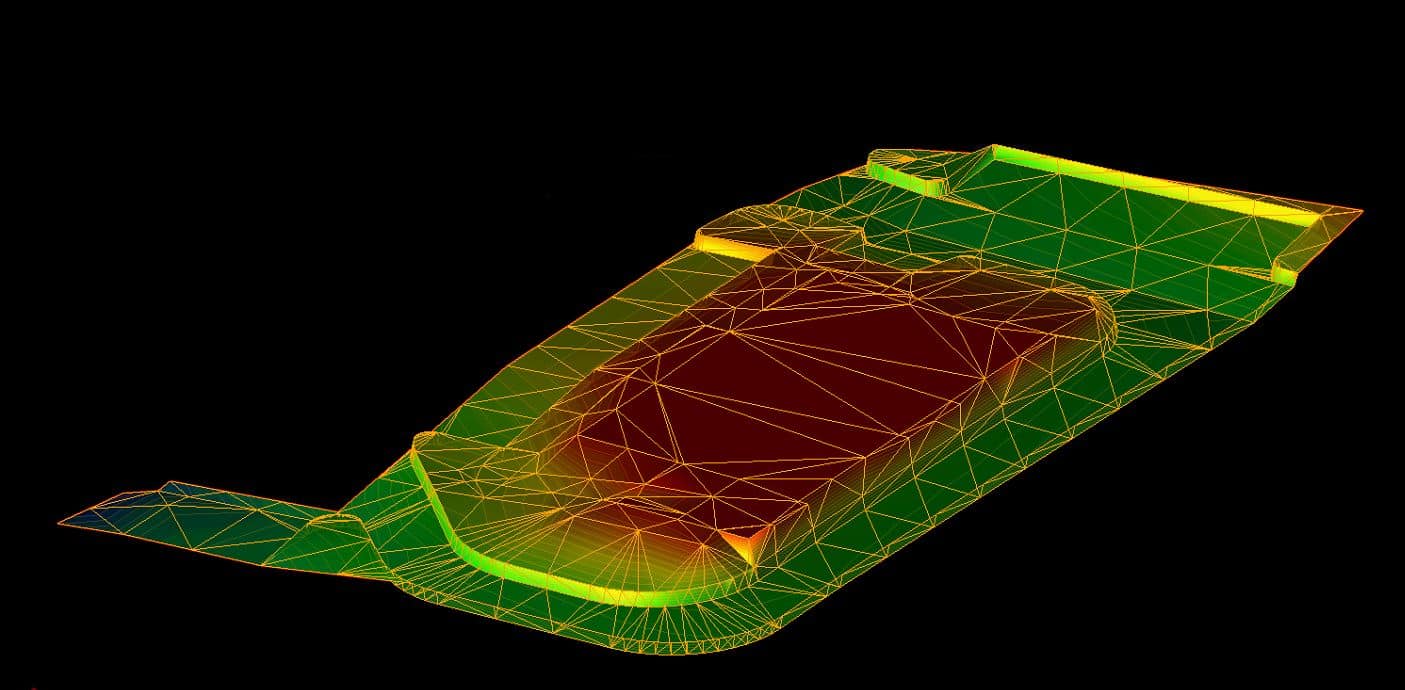
Digital surface models are 3D representations of the Earth’s surface. They depict the bare ground, including every above-ground ground structure — natural and artificial. This creates a comprehensive view of the specified topography, allowing professionals to learn more about the features of an area’s surface, such as the geometry, material composition and elevation. These tools are often more valuable than standard topographical maps by creating a higher resolution visualization with more precise characteristics to visualize construction projects, determine how land should be used and conduct environmental analyses.
Call us at 623-323-8441 to speak directly with a member of our team.
Request A Free Quote

Understanding Digital Surface Data
To reap all the rewards of a DSM requires dense and highly accurate data sets complete with images and measurements. This information is generally captured using various strategies and technologies before being loaded into software for creation. Whether surveying land, prepping a building site or generating an ideal evacuation route, the following strategies will ensure you collect viable surface data:
- Point clouds: Point clouds are coordinate sets existing within a 3D space to describe the shape and size of an object. They’re often generated using advanced LiDAR systems and light-structured scanners.
- Satellite imagery: Pictures from orbiting satellites supply valuable, top-down views of the topography and surface features. After removing distortion, these images offer a unique perspective for digital surface models by leveraging crucial elevation data.
- Photogrammetry: Photogrammetry captures numerous images from various locations and angles to facilitate meaningful calculations and insights. These images are taken by drones and then imported to intuitive software to extract elevation and surface-level data.
The Process of Digital Surface Modeling
Converting data points and images describing real-world objects requires specific planning and steps to generate an accurate DSM successfully. This process begins by determining your project’s scope and the kind of information you need to collect. With this complete, you’ll have a better idea of how to split up your data, decide on raster output models and realize how to best size your model for maximized success. Once your team better understands the goal and scope of your digital surface modeling project, you can get started with the following steps.
Acquisition
A model is nothing without the data it leverages. DSMs require accurate data points relating to surface structures like trees, buildings, roadways, and rivers. This information should comprehensively describe each object, including its shape, location, elevation, and texture. This data can be collected through any combination of strategies, such as 3D scanning, photogrammetry, and satellite imagery. Each strategy provides unique angles and sheds new insight into elements like surface elevations, building heights and terrain textures to facilitate the creation of a cohesive model.
Processing
Surface data must be imported into specialty software to be cleaned and organized. There are countless software options available, including AutoCAD, SketchUp and Blender. These programs offer tools and features to create precise visualizations while maintaining the ability to modify, update and adjust models continuously. You’ll want to classify the points into different categories, apply filters and reduce their density to develop an effective and usable model that generates meaningful insight into the land.
Reconstruction
Reconstruction is an important next step in designing a cohesive visualization. This is when you watch your data come to life, giving your data form and function. Interpolation and triangulation are two advanced processes that make this reconstruction possible. Triangulation involves creating a Triangulated Irregular Network (TIN), similar to a mesh, by connecting neighboring points through triangles. Delaunay triangulation is the most common type, which minimizes irregularities and maximizes triangle quality. Interpolation is a similar process used to estimate data points and fill in missing gaps to create a more consistent and accurate representation of the terrain and its elevation.
Quality Assurance and Utilization
Quality control checks are a staple of any digital surface modeling project. These inspections look for any errors or inconsistencies in your data by comparing the digital product to reference data. This step ensures you utilize high-quality information that strengthens your construction, environmental and communication decision-making procedures.
Once complete, you’ll have a precise and visually appealing DSM informing important analyses like hydrological modeling, slope stability assessments and terrain analyses, depending on your application.

Ready to discuss your project?

Benefits of Digital Surface Modeling
Take advantage of benefits like:
- Realistic visualizations: Digital surface models leverage advanced algorithms and tools to create accurate representations of specified terrains. They capture the size, elevation and texture of manufactured structures, natural landforms, and vegetation.
- Meaningful collaboration: 3D project modeling makes it easy for all levels of your business to understand your project development. Models can easily be shared, from shareholders to contractors, to facilitate meaningful teamwork and cohesive project completion.
- Efficient resource allocation: Understanding the landscape requires a significant investment of time and money, and DSMs can make the most of these resources. Digital models are quickly generated and are easily updated as needed to adhere to changing project demands.
- Diverse applications: DSMs are blank canvases that can be applied to various applications and situations. From designing a new building to understanding how climate change affects a specific area, this type of modeling can take many forms to ensure it provides information relevant to your project.
Partner With Our Team at TOPS
Having confidence in your 3D topographic models is paramount. At TOPS, we devote our resources to supplying trustworthy DSM services that contour to fit your specific project scope. Our 30 years of industry experience position us as the preferred data specialist and allow us to tackle over 1,000 projects annually. Throughout our time in business, we’ve evolved our technological infrastructure to remain on the cutting edge of the industry to deliver innovative solutions.
We’re committed to the data industry and are passionate about establishing lasting relationships with our clients to become a lasting partner. Our TOPS team comprises a dedicated group of surveyors, operators, engineers and technicians with high-quality licenses and certifications. Their expertise empowers us to handle DSM projects of any size, tackling every aspect of the required scope to simplify your workflow and generate meaningful results.
Three Simple Steps to Begin Your Project
To get started with TOPS, you just need to follow three easy steps:

Step 1: CAD Files
Provide the CAD files for the project in formats like AutoCAD .DXF and .DWG, among others. Files can be uploaded to their FTP site or shipped with the paper plans.

Step 2: Paper Plans
If sending paper plans, they will scan and store them electronically. You can transmit the scans or ship the paper plans.
Step 3: Work Order
Fill out a data prep work order on their website with the details of your scope of work. TOPS can accommodate various needs; just specify how you want the job to look.
We have no association with any manufacturer or system type but provide 3D models for all manufacturers
Get in Touch With Our Team to Learn More
Working with TOPS is the best choice to keep your surveying and mapping projects on track. We strive to provide a valuable service to our clients, ensuring a seamless partnership that simplifies your operation. The only documents our experts need are your CAD files, paper plans and work orders before getting started on a high-quality DTM that provides information you can trust. We work quickly and can often send you an email with your models within 48 hours when needed.
The professionals at TOPS are ready to supply precision terrain mapping services to offer more topographical insight across your site. You can reach out to our team online or give us a call to learn more about our services today.

