
For those outside the construction industry, it may be difficult to tell the difference between an engineer and a surveyor. Land surveyors and engineers work together on most construction projects and share some of the same responsibilities. That said, surveying and engineering are two separate professions requiring different skills and knowledge. Both disciplines are important in ensuring a project goes well, which is why you’ll commonly find them working on the same projects.
In this post, we’ll go into detail about the relationship between land surveyors and engineers and how that relationship plays out during a construction project. We’ll also discuss the different tools and methods engineers and surveyors use and how that impacts your project.
Collaborative Dynamics of Engineers and Land Surveyors
The duties of a civil engineer and a land surveyor are intertwined. They often work together on construction and civil engineering projects. While sometimes an engineer may take on the responsibilities of a surveyor or vice versa, both roles are critical to a construction project’s success.
Beyond the design phase, surveyors and engineers serve as checks and balances for a work site. Both supervise the construction process to ensure the structure is being built according to the original plans. Surveyors conduct as-built surveys, which they use to confirm the engineer’s plans. Engineers then use this information to create any modifications or corrections.
The point of their work is to ensure the crew builds to specifications and that the structure and worksite will be safe. If you were to lose either from your team, construction would have to stop until you found a replacement.
Surveyors and engineers usually work in teams, especially on large projects. In general, more complex projects require larger teams of surveyors and engineers. You also might use multiple teams as the project progresses — for example, you may have a team of surveyors at the beginning of a project and switch to another team if necessary.

The Critical Function of Land Surveyor Engineers
Land surveyors collect data on important geological features like the angles and distances between points above, below and on the surface of the land. They use this data to determine where a structure should sit and establish property boundaries. The types of surveys a surveyor might perform include:
- Property survey: A property survey confirms or establishes the legal boundaries between two pieces of property. This information is especially helpful in case a legal dispute arises between private and public parties.
- Geological survey: Geological surveys map out the physical landscape surrounding a site or structure, including features like rivers, mountains, valleys and more. Satellite data and aerial photography play a large role in geological surveying.
- Construction survey: A construction survey creates the layout for an engineering or construction project by establishing reference points, dimensions, elevation and positioning for a structure or proposed improvement.
- Deformation survey: Conducting a deformation survey helps surveyors determine whether a geographical or human-made feature changes shape over time. This information is useful for evaluating the chance that structures or improvements will be safe from the deformation of their surroundings.
- Right-of-way survey: This survey establishes access points and access rights to a particular property.
- Topographic survey: A topographic survey is one of the most important surveys a survey team conducts. It provides engineers with the locations of elevation variations, geographical features and artificial structures like underground utilities, telephone lines or nearby buildings. This data also allows engineers to calculate the earthwork a site will need to reach the final grade.
Land surveyors also play a role in minimizing the impact a project will have on the environment. When they take their measurements of the land, the survey team makes sure that the land will not be adversely affected, the structure will be safe and the project will be as efficient as possible overall.
Accurate survey data is also beneficial to the planning phase of construction projects. Here are some of the ways surveyors can aid engineers in the earliest planning stages:
- Mitigate the risk of future regulatory enforcement actions
- Maximize project startup through comprehensive planning
- Minimize delays in project schedules
- Help determine project scope and aid in pre-construction planning
- Establish standards for later survey teams to follow
Throughout the construction process, surveyors supervise activity to ensure the crew is following the engineer’s plans. Usually, these surveys require whole teams of surveyors to complete — more measurements must be taken on active construction sites than on empty land. If the project appears to be even a millimeter off, the surveyors steer the construction crew in the right direction before a problem can arise.
Once construction wraps, land surveyors conduct as-built surveys, which record the final location of a construction project and any deviations from the original designs that may have occurred.
Data Acquisition Techniques in Land Surveying
Surveyors use a combination of digital and conventional tools to create the most accurate image of a site they can. Some examples of surveying equipment include:
- Levels: Surveyors use levels to measure the difference in elevation between two points. Usually, they use these with level rods or tripods to get a precise reading.
- Prisms: Prisms allow surveyors to lock in control points at a height suitable for pinpoint accuracy. Surveyors can mount prisms on surveying poles and use them with electronic distance measuring (EDM) equipment for maximum accuracy.
- Theodolites: This essential surveying tool measures the vertical and horizontal angles between points. More advanced theodolites, also known as total stations, can also measure distances, complete calculations and record and store data for later use.
- Electronic distance measurement: EDM uses electromagnetic waves to measure the distance between two points. Surveyors typically use theodolites to gather this information.
- Drones: Surveyors can easily conduct aerial and high-risk surveys using drone cameras without putting themselves and others in danger. They can fly a drone into areas that are difficult for humans to access, like high bridges, canals and other civil infrastructure. The images produced through this process allow engineers to extract topographical data for their plans.
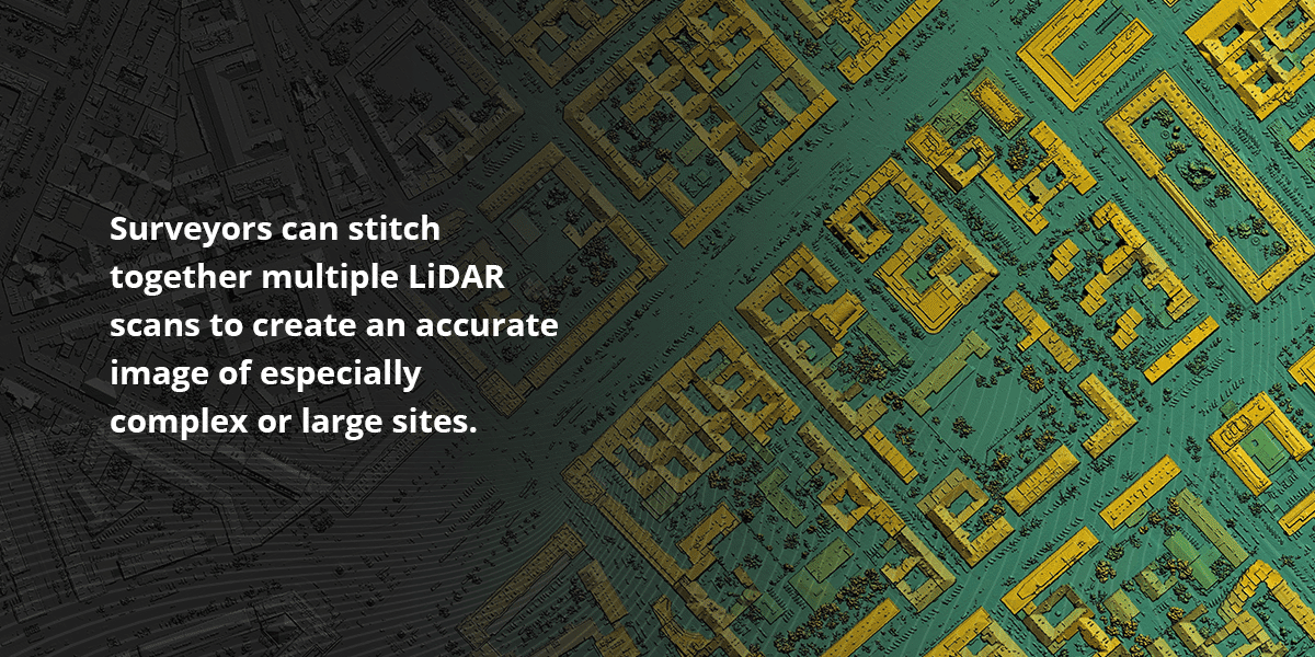
- LiDAR: Light Detection and Ranging (LiDAR) systems use pulses of light to create a point cloud, which serves as the basis for a detailed 3D model of a space. Surveyors can stitch together multiple LiDAR scans to create an accurate image of especially complex or large sites.
The Engineer’s Domain in Construction and Design
Once the land surveyors have completed data collection, civil and construction engineers use this information to create the blueprints for the project. If the structure requires a foundation, a geotechnical engineer is typically the one responsible for ensuring the foundation will interact well with the geographical features around it.
The surveyors often provide their input during the design phase as well. This feedback increases the chances that the plans will succeed.
Beyond the design phase, construction engineers are typically responsible for overseeing the design and safety of temporary structures used during the construction phase. They may also be responsible for the following:
- Preparing project budgets and communications
- Planning distribution of water supply and electricity
- Ensuring construction sites are safe and clean
- Providing technical advice and feedback to construction crews
- Selecting and procuring the appropriate materials for a project
The Crucial Need for Precise Data in Engineering
After surveyors have collected the necessary data for a project to begin, the raw data needs to undergo a series of processes in order for engineers to make use of it. Raw data can be messy and inaccurate, so it’s important to perform data preparation before attempting to use the information.
Data preparation is the process of cleaning and transforming raw data into a usable format. This process involves several important tasks:
- Eliminating extraneous or duplicate data and any existing outliers
- Filling in any missing values
- Making corrections to data
- Ensuring data fits standardized patterns
- Reformatting data to facilitate analysis
- Joining together data from multiple sources
- Consolidating or separating fields
The benefits of data preparation for construction projects include:
- Reliable results: With accurate, readable data, engineers are better able to draw plans that accurately reflect reality.
- Potential savings: When engineers have accurate information about a site, they can more easily identify areas where they can safely cut costs.
- Informed decisions: Accurate data equips engineers and project managers with the knowledge they need to make important planning and procurement decisions.
- Increased safety: More accurate site data means engineers will have a better idea of the potential risks involved with a project, which can help improve worksite safety and speed the construction process.
Because data preparation can be a time-consuming process, it can be beneficial to go through a third party. You’ll be able to focus all your time and energy on collecting geographical data and translating it into building plans while your data prep partner takes care of the rest. Plus, having more eyes on the data can help find discrepancies and errors you may have missed the first time around.

Various Specializations Within Engineering
Engineers who work on a construction or civil engineering project may specialize in a range of disciplines, including:
- Architectural engineering: Architectural engineers design buildings. While they have a similar job to architects, architectural engineers focus on the functional aspect of a structure rather than its aesthetic appeal.
- Construction engineering: Construction engineers are a subtype of civil engineers responsible for overseeing the design and implementation of large-scale building projects. Often, they are also responsible for developing project budgets and overseeing how the project works.
- Civil engineering: Civil engineers are responsible for overseeing the complete construction and safety of a construction project. Their primary focus is on ensuring the functionality and structural soundness of buildings and infrastructure.
- Geotechnical engineering: Geotechnical engineering involves gathering data on the behaviors of soil and rock. It also involves assessing factors like slope stability and the potential risk of landslides, avalanches or falling rocks. This information helps determine the makeup and design of a building’s foundation and how it contributes to structural stability.
- Structural engineering: Structural engineers are responsible for designing and assessing large-scale projects like bridges, buildings and dams to ensure strength and stability.
- Transportation engineering: As the name implies, transportation engineers focus on planning and maintaining transportation systems, like city streets and expressways. Surveying is crucial to transportation engineering because the condition of a road is often dependent on how well it interacts with the geological features surrounding it.
Unless the engineer has the skills and tools to conduct land surveys themselves, working with a surveyor is a must for any engineering or construction project.
The Technological Arsenal of Modern Engineers
In addition to the traditional paper and drafting pencil, engineers use a variety of computer programs to draw project plans, manage workflows and communicate with other parties working on the project. Typical examples include:
- Computer-aided design (CAD) software: Programs like AutoCAD, DraftSight and Solidworks allow engineers to create detailed, readable 3D plans for construction projects.
- Project management software: Tracking programs like Excel and Primavera are useful tools for tracking project workflows and progress. This kind of software also comes in handy when tracking and calculating material quantities or other data.
- PDF editors: Programs like Adobe Acrobat and Bluebeam Revu are excellent for marking up and editing designs before sending them in for review. Some have collaborative features that allow whole teams to view and edit a document simultaneously, enabling users to catch errors they may have missed in earlier stages.
The specific tools an engineer may need depends on several factors, including the types of projects they work on, their specialization and where they are in their career. For example, a new engineer is more likely to use technical software most of the time, while someone who has been in the industry for a while might use something oriented toward project management.

Enlist Expert Take-Off Professionals for Your Engineering Data Needs
The construction industry relies on good data to create safe, lasting structures — that’s what makes land surveyors and engineers so critical to the success of any building project. Both professionals gather and use data to plan projects and ensure they stay on track.
If you need to package data for your crew, TOPS can help. With more than 20 years of experience and a laser focus on data preparation, you can rely on us to create excellent deliverables for projects of all shapes and sizes. Our team consists entirely of engineers who work full-time to ensure you get the data you need when you need it, even when deadlines get tight.
All we need from you are your CAD files, paper plans and a completed work order. With this information, our team of engineers can create accurate, high-quality reports for your projects, including:
- Grading surfaces
- 3D utility layout
- Dirt and material quantities
- Cut and fill maps
- Mass haul analysis
Let us take some of the work off your shoulders. Reach out to request a free quote today — we’ll get back to you shortly with a detailed report and accurate turnaround times, giving you the confidence you need to win your bid and complete your project in time. We also offer free trials if you want a more detailed look at what we can do for you.