For this article I will go through the evolution of the way things were to the way they are today when working with local coordinates. The information is presented as fundamentals to your understanding of how GPS surveying works on a job site. Not being familiar with these concepts could cause issues along the way as you work through working with local coordinates.
JUMP TO SECTION
Talking Survey Coordinates
When performing a layout and surveying with a total station, level, chain, or a combination – equipment jobs are assigned coordinates based on a random northing and easting. For smaller sites, it seems the most common starting coordinate is 5000, 5000. The “bottom, left corner” would be the starting location of the assumed coordinate system so the numbers going to the north and east would get bigger. This also leaves room to the south and west of the start point to avoid negative coordinates – more on that later.
In the past, points that were to be laid out on a job were assigned coordinates that conformed to where the arbitrary coordinates started. This system works well, but we haven’t used it in years. Almost all our GPS based jobs are located on state plane coordinates. Later in this offering I will talk about the mechanics of a localization or calibration. It’s the same thing but different names depending on the brand of equipment you use.
Enter GPS Surveying
In the early days of GPS survey, localization was carried out by aligning GPS coordinates with the local grid assigned usually during the initial survey. Things worked well and the equipment wasn’t confused by the numbers. Somewhere along the way, people realized that their data could be monetized if it could be placed on a map in the correct location. A surveyor working in a town or city could use the control from surrounding jobs to locate control for a new job. That information would be worth money to both the city and GIS providers to enhance location services.
The shift to map coordinates was not immediate. One of the reasons was surveyors did not want their control being used for a neighboring job that they were not being paid for. Many also stated the additional liability of somebody using their state plane points and then something going wrong. It may not be their problem but that would be decided by lawyers, so it was best avoided.
Related Article: GPS Surveying Basics: Methods & Techniques for Accurate Data
Localization and Calibration
Autonomous GPS receivers used in cars and hiking units are incredible. We can geolocate within a few feet. This was not always the case. Selective Availability (SA) was an intentional degradation of public GPS signals implemented for national security reasons. In May 2000, the U.S government discontinued its use of Selective Availability to make GPS more responsive to civil and commercial users worldwide. When SA was in use, the best autonomous units could achieve was 50–100-foot accuracies. Great for travel or hiking, not so much for precision. Without doing a deep dive, we employed a base station to triangulate signal locations to give us the accuracy we see today.
How do we get the GPS to see us in state plane coordinates? A localization is required to sync these two different measurements. What you are doing is telling the GPS, “When I am at this Latitude, Longitude, and GPS height, tell me I am at this northing, easting, and elevation.” There are a couple of things to note in this statement:
- Latitudes, longitudes, and height are what the GPS is reading all the time. Our screen shows the coordinates we want it to.
- The units all use meters in the background, converting them to decimal feet at the end for viewing on the screen.
- It is important to note that I used the word “height” when talking GPS and elevation with state plane coordinates. GPS uses a mathematical ellipse to establish the not regular sea level. Your elevation will always be different, sometimes over 100 feet. Be sure you are talking about the correct type of tall.

Above is a shot of a few lines of a site calibration. This is the Trimble data collector file, (.dc)
- The origin Lat/North are in the first two rows. This is how we tell the GPS to give us desired coordinates for latitudes and longitudes.
- The horizontal adjustment is needed to force the points to match up. The translation and rotation of the points will usually never be an issue to you. When things do not work right, then you get deep into this data.
- Scale factor is usually the only thing you need to pay attention to. If you have a 1 followed by four zeros or four 9’s following a decimal point, then you should be good.
- The GPS must be mathematic, just like the ellipsoid used for mean sea level, your job gets tilted on an inclined plane.
- The vertical adjustment shows the slopes to the north and east from an origin point in parts per million. In this case, the slope to the east is .000058%. This is the reason you need to have multiple calibrations on longer jobs. In one mile, the vertical on this job could be off by three tenths.

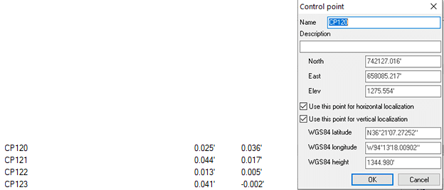
Here is a control file from a Topcon controller. I drilled down to control point 120 and was given the following information:
- The northing, easting and elevation of the point are either keyed in manually or imported from a text file.
- Upon occupying the point, the relationship is made.
- The residual values, (accuracy) are within my desired tolerance so I checked both the vertical and horizontal use in the control calculations for this point.
- Note the almost 70-foot difference in the local elevation and the GPS height.
Coordinate Confusion
Things do not always go according to plan. When something does not look right, it is probably wrong.
US and International feet
A source of confusion and sometimes great expense is that in the United States we use two different measurements for a foot. The difference is 2-feet per million feet. The problem is that state plane coordinated can be in the millions so a mix-up can put you several feet from your intended target. Six states use the international foot with the balance using U.S. feet.
States using International Measurement are:
- Arizona
- Michigan
- Montana
- North Dakota
- Oregon
- South Carolina
To make things even more complicated, the U.S. foot will be deprecated as of January 1, 2023 making the international foot the standard. There is a lot of commotion going on around the proposed change and as far as I can tell, it will happen. The biggest argument is that a majority of people and real estate use the U.S. foot, why not change to that? Time will tell, stay tuned.
A fun website
To help you navigate to any place on earth (and your big jobsite) easily, I have been using an app called What 3 Words, https://what3words.com. The world is now broken down into 3-meter squares. This has really helped emergency services as well as friends who can never quite get directions right. We use it in the field to tell people where we are meeting. It sure beats “go to the job trailer and keep driving.”

