
From the ancient wonders of the world to the modern buildings we inhabit today, surveying technology has been helping us measure for thousands of years. We’ve come a long way from the rope stretchers of ancient Egypt, but land surveying technology is still evolving. Like every industry, the future of land surveying is set to change in the coming years. Between an increase in drone usage, improvements in mobile 3D mapping and changes in data management, surveying has many developments ahead of it. The trends have implications for the industry that can improve data collection, change data storage approaches and offer more accessible and flexible information gathering.
Today we’ll be going over what the future of land surveying technology looks like and what some of the top land surveying trends are shaping up to be.
JUMP TO SECTION
Unmanned Aerial Vehicles (UAVs) in Surveying
Unmanned aerial vehicles (UAVs) have become more and more accessible and affordable, making them great additions to a surveyor’s arsenal. Before their widespread availability, they were often thought to be cost-prohibitive for many applications and were reserved for military use. Now, they offer several advantages over both terrestrial surveying teams and manned aircraft. Drones can:
- Cover large surface areas in a short amount of time
- Cross difficult terrain
- Take detailed images of hard-to-reach landscapes
- Accomplish land surveys, photogrammetry, 3D mapping, topographic surveying and more
Traditional methods often couldn’t complete these tasks, whether due to complex terrain or the sheer amount of time it would take with land-based approaches. Surveyors can now get their aerial data quickly and accurately with modern drones. UAVs also make the job safer, so human operators don’t need to fly over or enter hazardous environments to take measurements. Drones are becoming standard, less of a “bonus” and more of a necessary component of landscape businesses. Using them may soon become an industry standard.
Stay Current with Leaders in Surveying Technology
At TOPS, we actively stay up-to-date on the latest technology and industry trends in land surveying. With our fast, accurate quotes for 3D machine control models, and our dedication to advancements in the field, you can trust us to bring the future of surveying technology to your projects.
Expanding Drone Applications in Land Management and Development
Drones are also often used for cadastre, opening up a significant area of use. In addition, they can provide data that integrates with computer-aided design (CAD) software to build models for land development and management. Another benefit of drone usage is that it can provide a variety of photos for recording land data and structures.
Some other forms of data that you can collect from drones include:
- 2D Orthomosaic maps: Stitch together photos from a drone to create a top-down aerial view.
- 3D Orthomosaic maps: Stitch together images to compile a 3D birds-eye view of a space.
- 3D models: Create detailed models from powerful mapping software.
- Thermal maps: Record and identify abnormal heat signatures in an area.
- LiDAR point clouds: We’ll talk more about LiDAR in the next section, but drones can help you create a high-density point cloud for use with this system.
- Multispectral maps: Data outside the visible light spectrum can offer a variety of uses, including missile detection and satellite imaging.
- Building information modeling (BIM): Combine high-resolution 3D programmatic or laser models with pre-made BIM objects. This information can help to identify variations and respond accordingly.
When it comes to achieving the greatest possible accuracy, drones can use additional tools, like real-time kinematics (RTK) and post-processing kinematic (PPK) positioning. Both are positioning techniques that can improve the precision of the data using information from satellite-based systems.

Advancements in Mobile 3D Mapping Techniques
Mobile mapping systems can provide extremely detailed images in a short time. They are flexible and allow you to create 3D models from a wide variety of environments. Indoor, outdoor and underground areas can all be extensively detailed with mapping technology.
It is fairly straightforward to collect geospatial data and use software solutions for fast and simple mapping. Surveyors can create digital replicas without cumbersome equipment or the need to wait hours to see the results. Versatile equipment options, handheld devices and aerial recording make mobile 3D mapping a viable and effective approach for many land surveyors. Many of the sites a surveyor visits can be dangerous or difficult to access. While they could spend valuable time and money trying to get into the area on foot and use traditional terrestrial tools, a more efficient option would be to use a UAV. Plus, this method keeps them out of any treacherous terrain. Similarly, if a surveyor needs to make a model of an extensive area, they can attach their recording devices to a vehicle and move through the site this way, offering a less physically taxing job and a faster result. These methods require very little training and are easy for new users to operate.
Mobile 3D mapping is available without the use of GPS surveying and in durable, splash-proof products, offering additional flexibility. This kind of product can help you map out hard-to-reach places, whether they are dark, dank or dangerous, through several different methods. Tools are often made to be light and portable for ease of use.
One of the most notable benefits of this kind of mapping includes real-time, instant results. You can transform your data into 3D visuals quickly, reducing the time it takes to see results. 3D-mapping software also tends to offer robust organizational features, such as bundling data into projects and managing single uploads automatically. This organization can extend to mobile devices, including apps and third-party plugins. Some even provide features such as automated measurements, asset inventory workflows, face blurring and more to offer more of an all-in-one approach.
Enhancing Data Accessibility in Surveying
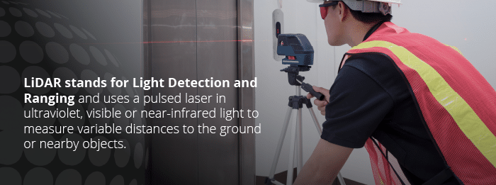
Another growing piece of technology is LiDAR, a form of 3D laser scanning. LiDAR stands for Light Detection and Ranging and uses a pulsed laser in ultraviolet, visible or near-infrared light to measure variable distances to the ground or nearby objects. The machine is composed of a laser, a special GPS receiver and a scanner, and they usually utilize airplanes and helicopters to gather their data across large areas. This remote sensing method collects information from the light pulses and other data collected from the aerial system to create detailed 3D models or gather survey information about the physical characteristics of the Earth.
Types of LiDAR Surveying Techniques
There are several different types of LiDAR, including:
- Terrestrial: This type of LiDAR maps the Earth’s surface through topographical measurements that are mounted on the ground. Surveyors can map 3D-point clouds from the scanner with digital images to quickly make realistic 3D models. It can bypass the cumbersome tasks of measuring each item, like power lines, bridges, trees and more that may be in an area.
- Bathymetric: Bathymetric LiDAR measures elevations of riverbeds and seafloors with the help of a green light that penetrates water and its reflection back to a sensor. The measurements are typically taken from the air.
- Airborne: A laser scanner can be attached to an aircraft and used to create a 3D-point cloud model of a landscape. It is detailed and accurate, helping to create digital elevation models (DEM) and digital surface models (DSM).
Applications of LiDAR Surveying
This system provides a new level of precision and flexibility to the measurement of both organic and manmade structures. It may also pave the way for the automation of vehicles and assisting in lunar-landing vehicles. LiDAR is growing in use in a wide range of applications:
- Agriculture: Topographical data from LiDAR can help identify patterns of sun exposure, insect behavior and features in the landscape to improve farming tactics.
- Archaeology: Archaeologists use LiDAR technology to help plan field campaigns, map features under tree cover and create DEMs of archaeological sites for more detailed images. For instance, in 2013, it was used to rediscover the city of Mahendraparvata in the Cambodian mountains.
- Atmosphere: LiDAR is used in meteorological applications to provide information on surface pressure, greenhouse gas emissions, fires and photosynthesis. It can measure backscatter from the atmosphere and reflections that scatter off a hard surface.
- Physics and astronomy: LiDAR can help measure distances and the position of the moon and create topographic information about other planets.
- Wind farms: LiDAR can measure wind speeds and turbulence to help optimize the performance of wind farms.
One of the major benefits of LiDAR is that it offers real-time point clouds. Not all systems have this option, but many do. This feature can provide significant advances in the way of speed and accessibility, making projects more flexible and efficient.
As LiDAR systems become less expensive and more accessible, they are likely to be more common in survey projects.
Outside of LiDAR, general data accessibility is likely to improve, as more advanced tools become more affordable. Products that were previously reserved for only the most prestigious of tasks, like those in the military, will become more commonplace and may even become industry standards.
The Role of Cloud Computing in Data Storage for Surveying
As scanning technologies have become more complicated and advanced, they have started to create more data. All of that data takes up valuable space and can quickly become a burden on the IT capabilities of land surveying organizations. Many of them don’t have the storage infrastructure to support such a growing amount of information in a physical, on-site data center. To remedy this, many companies are turning to cloud storage, in which data is kept off-site, in a secure location and managed by a third-party company. Often, these companies offer high levels of security with dedicated experts working around the clock to protect their clients’ data. Most importantly, it takes the burden of finding space for the data away from the survey companies. They can spend less time worrying about the security of their information and more time working on projects or investing in better equipment.
These survey organizations have to store data for thousands of projects, and they can repeatedly outgrow their capacity as they accumulate more projects and business. Cloud storage is scalable and allows land survey companies to leave the issue of storage capacity to their servicer. Storage infrastructure can be costly and time-consuming, so many organizations are aiming to offset these problems and let someone else manage their information. Similarly, processing power can also be scalable. Some point-cloud software uses significant amounts of processing power from an off-site cloud center to deliver high-demand results to the user. The option to beef up power when needed is often appealing to surveying companies.
Another reason that many companies are moving to cloud-based storage is for the ability to share and access data more easily. Cloud storage eliminates the need to send files, which is essentially copying and redownloading them, often resulting in duplicates or creating unnecessary data. As well as taking up extra space, this can lead to misinformation or outdated files. With cloud storage, users can instead access the same data, and they can do so from a variety of devices wherever they have a connection. In-field access is an excellent tool for surveyors, offering them the ability to upload scans and view data as needed while on-site.

Here are a few more reasons companies are moving to the cloud:
- Manageable costs: Startup costs for extensive data storage can be high, but many cloud data servicers run off of subscription models. This approach can make the service more affordable and predictable for land surveying companies, but it would also be a monthly cost rather than a capital investment. Organizations will have to decide if that approach is right for them.
- Reduced maintenance: Surveying companies don’t have to worry about updating or installing local software and may save on IT costs and time. Plus, they receive the help of dedicated digital storage professionals to keep an eye on things.
- High power: Some organizations need to run robust programs to read and analyze their data, which may take ages on a local computer. Cloud-based software can offer higher-powered programs that may be able to get the job done quicker.
- Automated scans: Some programs can automatically start registering scans into a composite point cloud as they are uploaded. This approach can speed up the process and even help surveyors access completed point cloud data from the worksite.
- Collaboration: Many surveyors have to work with a variety of partners, including contractors, engineers and other stakeholders. Cloud services make sharing data with third parties much more straightforward than before. Surveyors, management, engineers, clients and more can share information quickly and with controlled permissions, improving collaboration between parties. Surveyors can ensure that only those who need access can view the data, as well.
Though cloud-based storage is a powerful tool, it can change the way organizations operate. For those using massive amounts of data, costs can add up. Surveying companies must crunch the numbers and analyze their unique needs to find out if cloud data is right for them.
Collaborating with Expert Data Modelers in Surveying
For your data modeling needs, Take-Off Professionals has been creating accurate 3D models for over 20 years. Whether you are a contractor or surveyor, we can provide fast and accurate quotes for 3D machine control models.
When you work with us, you work with industry experts. Our team of licensed engineers, surveyors and 3D technicians ensures that we stay up to date on the latest technology and industry trends in land surveying. Whether its the ease of use and versatility of UAVs, the flexibility of mobile mapping or the changes in data storage, you can be confident that our staff is up to date on these topics and whatever comes next for the future of land surveying and surveying technology.
Learn more about our data preparation, quantity takeoff, and GPS machine control modeling services!