Disclaimer: This article does not contain health and safety protocols.
For years we talked about remote jobsite access where we could check a project’s progress by viewing live feeds from cameras and machine sensors. The mining industry has embraced this and my experience in this area will guide my thoughts and recommendations in this offering.
I will go through the COVID-19 workflow and outline some areas that you may want to invest in. These improvements will not be abandoned when the crisis passes but instead become necessary upgrades. When upgrading machines and software there might be components for the machine that need to be purchased. With the machinery improvements, the addition of software is required but not as cost intensive as upgrading machines.
Pre-Job Takeoff
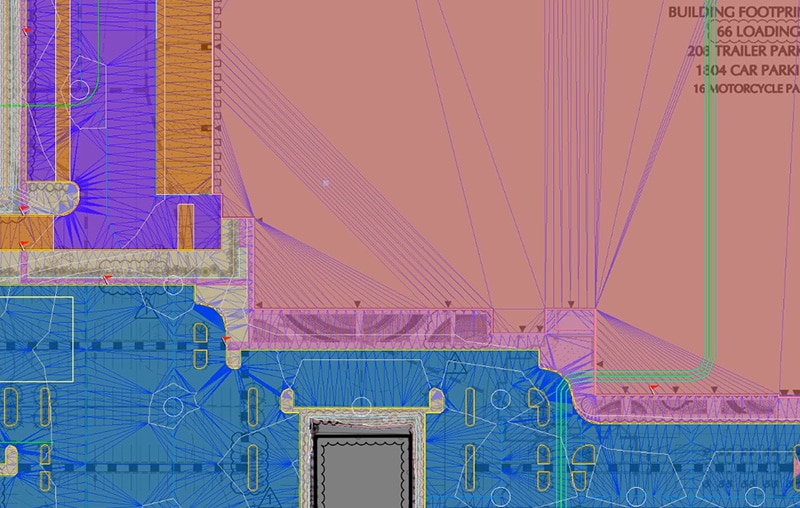
Yes, I am going to mention the need for a good topo which results in a good takeoff. Drone flights can be done safely with results returned to the office. What about a site inspection? You’ll want to get a look at the job and get a feel for it. That is the art of estimating – we leave the good dirt numbers we create using software and look at what it will take to make things happen.
Drone Flight Basics
Get the crew out and set control points for an aerial topo.
Fly with a drone to get nadir imagery for conversion to a point cloud.
Verify the quality of the data in the field.
Reconfigure the drone to a gimbaled camera forward and down view. This gives an angle to see elevated items visually and not rely on the point cloud.
Fly two different patterns.
Run the “lawnmower strips” but lower and with the camera at the described angle.
Free fly to get specific areas that may need closer scrutiny. Go all around stands of trees, old buildings, and stockpiles as you would do on a site visit.
Process the drone point cloud as usual.
Using the ortho image of the job, make notes regarding the detail flights such as where they started and ended. A dotted line of a special flight will help the user get oriented quicker.
Rename the special flights and correspond the name to the legend on the map.
Have someone review the files you submit without explanation. After a few jobs you will be able to present a takeoff topo to the estimator that needs no further explanation.
Bidding
Not to go off into the weeds regarding proposals, but these times have created some special demands. Many of our clients are putting in disclaimers and questions in the bid for further clarification. We have even seen “if/then” line items so the owner knows what to expect if the pre job images could not tell the entire story.
Once the job has been won, it’s time to go to the field. Here are some ideas to consider.
The job trailer may be a thing of the past. Nobody can really go in so all it becomes is storage. Consider a smaller windowless container instead. With site visits being reduced, we need a way to communicate and keep everyone in the loop.
Job Meetings
We have had to make a quick shift from in person meetings to all remote interaction. This brings up a host of new challenges.
File Access
People need to see what is being done. Set up shareable folders online to give the right people access. Here is how this changes what gets shared.
Limit the ability of users to post files to your collection. Too many people adding documents can make a mess.
Use a separate folder for input from those outside your work group. Review the added file and keep it there or put it in the main slipstream for others to review and comment.
Turn off update notices. Doing this at the start will disable sub-folders as well. When something big has changed, let those that will be affected know.
Get file structure sorted before the project begins. You can waste hours looking for something in a rat’s nest of file trees and sub-folders. Yes, there will be a lot of files. They are usually updating to base versions. There can be a lot of folders with new and old files available to review. Maintain the dates for these folders but keep the structure and hierarchy.
Meeting Basics
Now that we are all virtual, there are some things that must change for things to keep moving smoothly.
Learn how to use your conferencing platform. Know how to mute, operate your video, and change backgrounds.
Learn how to get your face to look correct. Take a moment to review your video feed and learn what light looks good.
When using a cell signal for conferencing, things can get slow and you may miss a lot of dialog. Turn off your video to improve audio reception.
Have ONE person run the meeting. Weekly meetings should have the same person and agenda; yes it will change but keep the structure consistent.
The worst thing with remote meetings is everybody talking at once. To get over this, we have used raise hands, chat in a speak request or question, and going around the screen for comment or pass.
Virtual meetings do not have the same impact of in-person. After every meeting, somebody needs to distribute notes as to who said what and what happened so it can be reviewed and commented on.
Never have a meeting that could have been an email. How do you avoid this? Send out the item(s) as an email first. If there is too much comment or lack of agreement, then it gets to go to a meeting.
Change Orders
Simple change orders are no longer simple. Usually there is a site meeting, and the problem is hashed out. We have helped clients with this issue and there are steps to take that will help reduce the hassle. Start in the field, then move the information to the office.
Field Work
Just like with the takeoff, images will be the key to stating your case.
Drone and ground video with narration done in the office are worth a million words.
Collect topo data if needed.
Take a narrated cell phone video to explain the details to the office so the presentation is clear.
Office Work
With field data in hand, start to build a story that walks through the problem and proposed changes.
Always propose an answer.
Go through the data provided by the field and create the story. Bullet the high points to help with the steps of toe issue and a fix.
Talk to the field people in an online meeting to verify you have the details right.
Have the field collect any additional information needed to clarify things.
Now is the time to make the short, clear story for a person who has not been on the site to feel like they are.
Images and video with narration as well as the text of the narration included as a Word document are key.
Send the information back to the field and have them review. If it makes sense to them, you are good to go.
Do not schedule a meeting! Send the data to the parties involved for them to review and if there are too many questions or issues, then go to a meeting.
Use their questions and concerns to improve your template for subsequent presentations.
After a few of these, you will be quick and concise.
Summary
Nothing that I have mentioned will die with COVID-19. When we come through this, the ease of performing these ideas that I’ve outlined will continue to live on.
Upgrading machines to generate topo data as well as dirt movement is something worth looking into. I will cover this in a future offering.
Do not be concerned about the software expense and additional training. As you may know, we conduct our business remotely and have been employing these tools for years because we do not live near any of our jobs. From a quick markup of plans on Bluebeam, or a complete presentation with information provided by our client, we make difficult subjects clear.
Start doing this with small items to get your list in order. On larger issues, follow the same playbook and watch how easily and quickly things come together.
Civil surveying is essential for the success of many construction projects, from residential and commercial buildings to infrastructure. It gives project managers and engineers the geographical information they need to build a structure that will stand up reliably in the local terrain and helps them map out how their project should unfold.
Within civil surveying projects, 3D modeling using survey data is a vital technique. The Federal Highway Administration recently analyzed an interchange project in Milwaukee, Wisconsin, and found that the use of 3D modeling reduced operational costs by up to 30.5 percent, especially in the construction of general structures, drainage and bridges.
But what is civil surveying, exactly, and what different forms does it take for different projects? In this guide, we’ll discuss what surveying in civil engineering is, its purpose and how different types of new technology help accomplish civil surveying goals.
Fundamentals of Civil Surveying for Project Success
Civil surveying is an engineering operation that involves assessing and recording details about an area of land. These observations can then be used to help plan construction projects.
The main purpose of surveying in civil engineering is to determine the three-dimensional relationships between different locations. Knowing information like the distances and angles between points and lines helps engineers determine how to draw up plans for public buildings, homes, roads, bridges and a variety of other construction and infrastructure projects.
The points that engineers measure are often located on the surface of the earth, though they can also be located in space. Because intricate, precise spatial relationships and boundary lines are so integral to this process, civil surveying draws on aspects of different disciplines, from mathematics to geography to law.
Civil surveying also involves specific equipment and GPS data acquired from satellites. High-precision electromechanical and optical equipment is also a necessity for ensuring measurements are accurate.
Elevate Your Construction Project With Expert Civil Surveying
Looking to kick-start your construction project? At Take-Off Professionals, our experienced in-house engineers offer tailored civil surveying solutions for commercial sites, residential sites, and road work operations.
The Critical Impact of Civil Surveyors in Construction
So, what is the importance of surveying to civil engineers? Surveying gives civil engineers a complete story of the land. It reveals details about topography, existing structures, natural elements and concealed conditions, all of which are essential to know before designing and proposing a project. Data from surveying enables civil engineers to understand site limitations and possibilities.
Civil surveying is useful in a tremendous variety of different applications across industries and project scopes. A few uses include:
Creating maps: Surveying is all about data, and with that data, engineers can generate topographical or marine navigational maps that provide needed accuracy for project development.
Preparing plots: Engineers can use surveying to determine boundary lines, calculate alignment and accomplish other tasks to prepare plots for various project requirements.
Planning for newprojects: Construction surveying enables engineers to inspect high-risk areas, ensure safety, conduct impact tests and determine optimal structure placement as they begin planning new projects.
Estimating projected pathways: Data from surveying provides the information engineers need to estimate effective paths for roads, railways, power lines and irrigation systems.
Assisting with land disputes: Surveying allows civil engineers to assess and record the boundaries of different properties to determine land ownership and settle legal disputes.
Analyzing topography: Engineers can gather valuable information about terrain levels, elevation changes, existing structures and more from the data surveying provides to improve project efficiency and safety.
Assessing existing structures: Data can reveal the position of existing structures like highways, canals, dams and bridges so engineers can understand what new structures will work within an area and which will not.
Planning and constructing mines: Surveying can help engineers find underground resources, enabling them to effectively scope out potential locations and discover information about mine and tunnel dimensions.
Preparing for military operations: Data from land surveys can assist with military operations and engagements by helping prepare maps and detailed plans that support various mission types.
Charting navigational routes: A survey can determine safe navigation routes on land and water by measuring angles, finding distances and calculating positions.
Top Three Advantages of Professional Civil Surveying
Because a construction survey performs so many functions, it’s a vital component of any civil engineering project. It provides crucial information needed in multiple project stages, from site inspections and planning to impact monitoring and risk assessments. Civil surveying offers the data engineers require to understand natural features and human construction and develop effective plans.
Surveying offers three main benefits:
Improved safety: Surveying assesses risk areas and hazards on a work site, enabling civil engineers to identify and resolve potential safety issues early on in a project. Surveying data can provide the necessary information to ensure structures are safe and protect the surrounding environment. Surveying technology can also increase job site safety through innovative tools.
Enhanced efficiency: Civil engineers can improve their project’s efficiency with surveying data. Precise measurements can decrease errors and streamline operations such as earthmoving to save time, money and effort. Surveying helps engineers ensure structures are placed in optimal positions for better site preparation.
Increased accuracy: Surveying provides accurate data about every aspect of the project site to help civil engineers draft comprehensive proposals. Better accuracy leads to better preparation, value estimation and project outcomes. Land surveying also enables engineers to establish accurate boundaries that prevent legal disputes and save time.
Tracing the Evolution of Civil Surveying Practices
The history of civil surveying goes back to ancient times. Egyptians used geometry to reestablish farm boundaries after dramatic flooding along the Nile River, and they used surveying techniques to design and construct the massive, geometrically precise pyramids at Giza, one of the wonders of the ancient world.
During Roman times, the role of civil surveying took on a prominent place in society, becoming an established profession. Land surveyors created the measurement systems they needed to evaluate and create a tax record of the lands they had conquered.
In the eighteenth century, European surveyors developed the technique of triangulation when they realized they could use different angle measurements taken from different places to pinpoint a precise location. And as the British colonized Australia and New Zealand, they used new tools such as measuring wheels, Gunter’s chains, Kater’s compasses and circumferentors, though they also resorted to measuring out paces by foot when necessary.
Gradually, tools like Gunter’s chain — which measures a precise 66 feet, or 1/80th of a mile — gave way to steel bands and invar tapes, and later to electromagnetic distance measurement (EMD) and global positioning satellite (GPS) equipment. Likewise, compasses gave way to theodolites — instruments that measured horizontal and vertical angles with a rotating telescope – which in turn made way for total stations that took measurements of angles and distance with a solo instrument.
Diverse Disciplines within Civil Surveying
Although construction is the most common type, engineers need to survey a wide range of features, from mountains to oceans to rivers. Engineers use several different types of civil engineering surveys, including:
Construction surveying: Construction surveying is useful for assessing the arrangement of the buildings, roads, power lines, gas mains and other structures surrounding potential construction sites. Analyzing this information makes it easier to plan construction projects.
Deformation surveying: Deformation surveying helps to establish if a geographical or man-made feature, such as a road, foundation, coastline or river, is changing shape. In deformation surveying, engineers record the three-dimensional coordinates of specific points. After some time has elapsed, they record the coordinates again to see if they have changed. A comparison of the two data sets can reveal if deformation or movement has occurred.
Geological surveying: Geological surveying maps out features of the physical landscape, such as rivers, valleys, mountains and more. Satellite data is essential for geological surveying, and engineers frequently use satellite data or aerial photographs to help them in their work.
Hydrographic surveying: Hydrographic surveying is similar to geological surveying, but it maps out coastlines specifically. Accurate hydrographic surveying is crucial to the work of the Coast Guard and any marine rescue operations. It also helps create navigational maps for sailors and assists conservationists in managing coastal resources.
Topographic surveying: Topographic surveying analyzes the shape and physical features of a particular landscape. Engineers assess the height of different geographical coordinates and then draw contour lines to indicate areas of the same elevation. They can then use these findings to create topographical maps and to assess terrain for future building or infrastructure projects.
Technological Integration in Modern Civil Surveying
Since ancient times, engineers have developed a host of tools to help them survey all types of features. As surveying needs have evolved, so has technology. Surveying devices have changed and adapted to modern needs to bring engineers the increased accuracy and speed they require to ensure safety and efficiency for a variety of project types.
Significant Technological Shifts in Civil Surveying
Technological advancements have had a significant effect on the surveying industry, enabling surveyors to do more with less. Instead of multiperson teams carrying around large, complex and heavy equipment, surveyors can work alone or in small groups with minimal equipment. Surveying simplification has brought about important changes such as:
Greater accuracy: Modern technology has improved accuracy in several ways, from the way data is gathered to the way it is recorded. Devices can accurately measure terrain, however uneven or difficult to access, and instantly record the data. These devices reduce chances for human error and provide precise measurements that improve overall accuracy on the job site.
Increased speed: Many devices can produce accurate results in a matter of hours, saving time on data collection and enabling engineers to get to work sooner. Most modern surveying technology requires little effort and time to use, also helping to decrease in-field time. Surveying large areas is easier and quicker with technology that can gather thousands of data points in a second.
Broader scope: Surveying technology can expand project scopes, enabling engineers to survey water and airspace in addition to land. Many devices allow for remote surveying to increase survey areas, especially for difficult-to-reach places. Surveying technology can quickly, accurately and safely assess areas and gather data for a wide variety of project types.
Improved efficiency: Modern surveying devices have simplified the surveying process to enhance job site efficiency and productivity. They reduce labor requirements since most devices only need one or two operators, and they contribute to lower labor and equipment maintenance costs. Surveying technology also allows workers to continue working with minimal interruption.
Expanded opportunities: Because surveying technology delivers more accurate data faster than ever before, engineers have more opportunities to innovate. Surveying devices provide ample information to maximize space and exceed project expectations. Engineers have more data and resources to ensure buildings, roads and other construction projects are sturdy, reliable and safe.
In modern civil surveying, different types of technology are available to meet unique project requirements. These technology advancements offer greater precision and better data visualization, giving engineers the detailed information they need to ensure safety, efficiency and accuracy.
Technology used in current civil surveying operations includes:
Computer-assisted drawing (CAD): Once engineers have gathered survey data, computer-assisted drawing helps turn that data into a useful visual representation, such as a map or three-dimensional model. CAD allows for a greater level of precision and detail than could not be achieved with manual sketching or drawing.
Global positioning satellite data: GPS survey data is crucial for civil surveying because it allows for the pinpointing of precise locations and coordinates. Where a visual assessment alone would be insufficient for determining whether a corner had shifted or a foundation had sunk, the pinpoint accuracy of GPS data allows engineers to know for sure.
Aerial photogrammetry: Drones are often useful for the aerial photography necessary in civil engineering. Once they have a number of aerial photographs of the landscape or site in question, engineers can use aerial photogrammetry to extract topographical data from the photos. Aerial photogrammetry combines multiple shots from different angles to create an accurate 3D model.
Point cloud modeling: To develop accurate 3D survey models, engineers also often create a point cloud or a set of three-dimensional data points. Surveyors use 3D laser-scanning technology to generate a data map of the area they wish to model. Once they have data that represents every surface they need, they can then bring the points together through point cloud modeling into an accurate and detailed 3D model.
Visionary Perspectives: The Civil Surveying Landscape Ahead
Surveying techniques and technology have come a long way since the days of the ancient Egyptians, and they will continue to advance and adapt as surveying and construction demands increase and change. Upcoming technological advancements will be integral to the successful and effective future of surveying.
Innovations on the Horizon for Civil Surveying
Recent technological developments that are increasing in popularity within the surveying industry include:
LiDAR: Light detection and ranging (LiDAR) is a growing and innovative technology that enables engineers to gather data quickly and accurately. Some systems provide real-time point clouds, offering the speed and data accessibility engineers need to keep projects moving forward. LiDAR technology advancements strive to provide precision and flexibility that benefit a wide variety of industries and project scopes.
Mobile 3D mapping: Improvements in mobile 3D mapping open several opportunities for increasing project safety, accuracy and efficiency. This technology enables surveyors to map difficult locations with versatile and portable equipment. Mobile 3D mapping also offers real-time results for faster, more streamlined decision-making.
Drones: Unmanned aerial vehicles (UAVs) are increasingly common on construction work sites as they become more accessible and affordable. Drones can cover large, difficult-to-reach areas quickly and efficiently, enabling greater site safety and productivity. As UAVs continue to advance, engineers can experience improved accuracy and speed in surveying and project development.
Data storage: Advancing technology gathers more and more data that needs to be stored and managed. Cloud storage is becoming increasingly popular and even necessary as surveyors search for a scalable data storage solution. Data storage will be a top priority as surveying technology continues to evolve.
How Emerging Technologies Reshape Civil Surveying
As technology advances, the civil surveying industry can expect to see changes in aspects such as:
Speed: Technological advancements lead to more efficient devices that improve surveying speed. Surveying technology will only get faster at collecting data and producing results for streamlined operations.
Expertise: Changes in technology will mean changes in required expertise. A valuable surveyor will be one who stays updated on the latest technology trends and can operate innovative devices such as UAVs.
Safety: Improvements in technology can lead to increased job site safety. Many surveying devices can travel into or scan dangerous areas, enabling surveyors to remain safe while still collecting valuable data.
Decision-making: Innovative tools will continue to make data collection quick and precise. This consistently accurate and accessible data will allow engineers and clients to make valuable decisions early on in project development to enhance results.
TOPS: Your Ally in Precision Civil Surveying
When you need 3D modeling expertise to get a construction project or bid off the ground, Take-Off Professionals can help. All our engineers are full-time employees, never contractors, so you’ll always work with someone who is fully integrated into the company, experienced with our techniques and invested and in the success of your operation.
We also stand apart from the competition because we don’t manufacture or sell hardware or software — we specialize only in takeoffs. That specialization has allowed us to develop an unparalleled wealth of technical expertise and vision in civil surveying. We can optimize our work for commercial sites, residential sites, and road work and highway operations, so you’ll always get the customized surveying solution that works best for you.
Surveying is a profession that requires patience and accuracy. Companies across many industries need surveyors to evaluate large plots of land and provide them with detailed mapping and measurements. From construction crews to archaeologists, having an aerial view or 3D model of a worksite is essential to starting and finalizing their work. Without these images or models, workers can’t make informed plans about where to dig, what to fill or where to start building. But surveying in the traditional methods and creating precise mapping takes time.
Drones, otherwise known as unmanned aerial vehicles (UAVs), have been changing the way surveyors work. With their rise in popularity, manufacturers have created drones for a wide variety of purposes, including utility models for companies that need to inspect or collect aerial images of worksites. This guide to land surveying with drones will explain what UAV surveying is, how UAV surveying is being done, what they work well for and how accurate of an image they provide.
The Emergence of Drone Mapping in Surveying
Drone mapping is the process of surveying an area of land with a UAV. An operator flies the drone over an area of land, taking hundreds of pictures as it moves. Then, with the help of computer software, they stitch and layer the images, creating a model of the site. This process is also how drone photogrammetry works, and the end result is an accurate 3D representation of the area.
Diverse Applications: Who Benefits from Drone Surveying?
Many industries require surveyors to provide maps of areas of land. From establishing the general grade of an area to creating detailed maps of every square foot, drone surveying makes the job easier, faster and safer for surveyors. Among the many industries land mapping with drones, some of the most significant include:
Construction: There are many answers to how drones are used in construction. Companies need surveyors to start almost any project, but they especially require their help on large-scale builds. Drone imaging aids them in establishing plot boundaries, creating legally acceptable subdivisions and evaluating the suitability of the land before beginning any foundations. With the provided information, construction companies can make important preliminary decisions that ensure optimal safety and legality for the project.
Oil and gas: The installation of oil and gas pipelines requires a significant amount of planning. Drone surveys help these companies evaluate where pipelines can and can’t go, whether it’s due to proximity to natural resources and conservation sites, preexisting construction or infrastructure or privately owned property.
Infrastructure: When it comes to designing and constructing new roads and bridges, infrastructure companies need to know the details of the surrounding land. Drone imaging can help them examine areas and determine if they need reshaping or if the land is suitable for construction in the first place.
Archaeology: Before archaeologists conduct digs, they need to survey the area to decide whether or not it looks like a promising location. Using drones allows them to do so quickly and at minimal expense, saving them time and allowing them to pinpoint interesting areas.
Mining: Quarries and open mines can be dangerous areas for traditional surveyors, but mining companies often need a mapping of their worksites. UAVs provide an excellent method of capturing aerial images and creating computer models while keeping their surveyors as safe as possible.
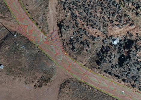
Navigating the Accuracy of Drone-Assisted Land Surveys
Before drones had an impact in the surveying field, creating accurate maps or 3D models of large plots of land would take anywhere from days to weeks. Now, UAVs allow surveyors to create models of comparable precision within a much shorter period. But accuracy in the surveying industry doesn’t have a single definition, and many different models of drones are available.
To understand how well drones perform, you have to consider several factors in regard to accuracy. There are many potential influences as to how well a drone can photograph an area. You also have to consider what you’re using the map or model for and what your standard of accuracy is for the given project.
Decoding Survey Accuracy in Drone Technology
One of the most essential details to consider is the drone’s operating pixel size. The spatial resolution of the UAV, also called the ground sampling distance (GSD) in technical terms, is the measurement of the space on the ground between two side by side pixel centers in the image. A drone’s GSD depends solely on the specs of its camera, including its resolution and focal length. Different camera models will provide different resolution qualities, resulting in varied GSDs.
When it comes down to measuring precision based on pixel size, your judgment should be based on positional accuracy. Essentially, this means the degree to which the model created by photogrammetry corresponds with the real world it represents. Still, there are two ways of looking at the accuracy of your mapping — relatively and absolutely.
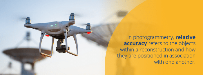
Gauging the Precision: Relative vs. Absolute Accuracy in Drone Surveys
In photogrammetry, relative accuracy refers to the objects within a reconstruction and how they are positioned in association with one another. This applies to any orthophoto map, digital surface model or 3D mapping.
Relative accuracy is an acceptable form of measurement for most cases where the surveyor is dealing with a smaller area or simple uses. It can be helpful for providing general volumes, heights and distances, as well as recording vegetation. However, it’s not the most accurate mapping you can obtain.
Achieving Pinpoint Precision with Absolute Drone Surveying
Whereas relative accuracy is more general and based on its own proportions, absolute accuracy is based on a geodetic coordinate system. It takes the measurements between objects within the model and compares them to their real-world positioning relative to Earth.
Having a geodetic reference system to apply allows the surveyor or digital model creator to complete more complex functions. For example, they can create professional documentation of surveying, use the recorded geographic coordinates and combine layers for more comprehensive data sets.
Absolute orientation uses ground control points (GCPs), which allow the surveyor to create a coordinate system through the known coordinates of visual landmarks within the image. But to obtain an absolutely accurate mapping of an area with drone imaging, you have to begin by measuring GCPs through professional GPS surveying.
Key Factors Shaping Drone Surveying Precision
Many elements can affect the accuracy of your drone mapping, especially if you’re dealing with the precision of an absolute accuracy model.
First, there are the apparent influences, such as the drone’s ability. Higher quality drones will perform better, from the stabilization mechanics to the camera. Beyond hardware, there are also plenty of outside factors, such as the terrain itself. Particularly rough or uneven terrain can throw off measurements and make it difficult to create a fully accurate mapping. Weather also significantly comes into play, as heavy winds and precipitation can affect the flight speed and stabilization of your drone, especially at high altitudes.
One of the biggest factors that can impact the photogrammetry process is your GCP measurements. However you identify these crucial points, your model can only be as accurate as your starting markers. To create the most exact mapping possible, make sure you measure the GCPs with a smaller unit than the pixel size of your drone imaging. For example, if your drone camera provides an image with 1-centimeter pixels, you should measure the points within a single centimeter of accuracy.
Absolute accuracy essentially builds on relative accuracy, meaning you have to have a proper relative model within the absolute one. Therefore, the accuracy of the absolute model depends on how precisely you measure your foundational relative model. Drone mapping involves taking potentially hundreds of photos with a non-metric camera and stitching them together to create a single image. More often than not, this means not every pixel will be sitting in the perfect position in your relative mapping.
Understanding Drone Survey Precision Limits
While photogrammetry provides surveyors with a far more accurate means of creating a digital model than other methods, no imaging can be perfectly precise. The ultimate goal is to create a model with the smallest degree of difference possible.
For relative accuracy, it’s expected that maps will have a horizontal and vertical error margin of one to three times the size of the pixels. For absolute accuracy, the margin should be a bit smaller, typically measuring at about one to two ground sample distances (GSDs) horizontally and one to three GSDs vertically. Even if your mapping lies outside these parameters, it may not be an issue, as particularly rough terrain can throw off measurements more than flat or level surfaces.
Drones are exceptionally capable of staying within these margins of error, as long as a trained and experienced surveyor is operating the machine. You can improve your accuracy by way of additional measurements between landmarks, using GPS reference points besides GCPs, improving your drone’s hardware, ensuring you’re working in favorable weather conditions and carefully stitching together the base images.
Legalities and Logistics: Drone Surveying Authorization
As the use of UAVs has been becoming more prevalent in industrial and recreational applications, the regulations have also increased. Before you can begin using industrial-grade drones to your advantage, you need to obtain legal permission to use them. However, it isn’t a particularly challenging process.
The Federal Aviation Administration (FAA) has control over all methods of aviation, including UAVs. To use drones in a commercial capacity, the official operator needs a Part 107 remote operator’s license. Essentially, it ensures you are knowledgeable about proper use and following regulations. To obtain the FAA license and maintain its validity, you have to:
Take and pass a test of your aeronautical knowledge at an official FAA testing center.
If you pass, acquire your small rating Remote Pilot Certification.
Register your drone with the FAA and renew the registration every three years.
Retake and pass the aeronautical knowledge test every 24 months to retain your license.
Follow all FAA regulations, which include but are not limited to drone and control system inspections before operation as well as reporting any accidents that result in injury or significant property damage to the FAA within 10 days of the event.
Once you are a licensed operator, you can use your drones to inspect any areas you are permitted to survey by the landowners. It’s up to you to gain permission to access areas marked private property or land plots owned by companies.
The Expansive Reach of Drone Surveying Across Industries
The benefits of drone surveying cross over many different industries and provide an accurate method of inspecting and evaluating small or large areas of land. These areas may be bare and ready for developments, they may have thick vegetation or they may even already have developed construction. Since there are many purposes for drone surveying, their usefulness applies to many different areas. From flatlands to deep pits, drone imaging provides an excellent way to safely and precisely create models of an area.
When it comes to how drones are used in surveying, there are many answers. Some of the most significant uses include:
Innovating Land Development with Aerial Drone Insights
As technology has improved over the years, land departments have become more inclined to use drones to provide comprehensive land recordings of real estate or property. Drones suitable for land surveying can take orthomosaics, also called orthophotos. Orthomaosaics are groups of multiple aerial phots of an area edited together to form a single image through photogrammetry.
Land departments use orthophotos for things like developing single object mapping layers and updating land cover on preexisting models. They use it even more frequently to create topographic maps for new developments, such as various forms of building construction or designing noise barriers.
Urban Planning Enhanced by Aerial Drone Mapping
Drones are exceptionally useful for surveying many different types of land sites, and they make management far easier for the responsible parties. They have nearly a limitless amount of potential applications and services, such as using the digital surface models produced by the drones to create virtual models of plots. They’re particularly useful to urban land management.
Those working within the industry can use drone surveying to import images into computer-aided design (CAD) software to create accurate virtual models of developments. With orthomosaics, which are essentially stitched and overlapping images, management teams can create defined boundaries with the benefit of a precise, aerial view. They can even use the models for more complex functions, such as simulating where water would flow and settle in the event of a major flood and creating a plan to redirect it.
Revolutionizing Construction Projects with Drone Overviews
When it comes to planning for construction, surveyors and the various landscapers and builders are responsible for a lot of preparation. They have to calculate cut and fill projects, complete surveys for pre-construction and as-built properties and oversee the details of the site from preparation forward.
Drone surveying provides these workers with a revolutionary method of imaging and plotting construction sites. It allows them to create an accurate model and plan without continually needing to access the physical job sites, saving time and money.
Drone Usage in Mines and Quarries
Surveyors don’t always have the benefit of a safe site. Mines and quarries can pose a safety risk, especially for those attempting to inspect a site at ground level. Geologists and surveyors benefit from using drones as an aerial method of inspection, enabling them to collect accurate data and spatial measurements while lowering the occupational hazards. They also help to boost productivity in quarries and pits, as drone imaging allows workers to make improvements to planning and inventory management.
Drones in Archaeological Exploration
Beyond companies looking to build and remodel areas of land, there are still many uses for drone surveying. For one, they’re particularly useful in the field of archaeology. With drones, archaeologists can create 3D surface models and high-resolution mapping of potential excavation sites. Doing so allows them to inspect and assess the worthiness of large areas of land much faster and with more accuracy than any other method. It’s efficient, cost-effective and saves their teams a lot of time and energy.
Precision Modeling for Your Projects with TOPS Drone Services
Whatever industry you’re a part of, Take-Off Professionals (TOPS) has everything you need to create accurate 3D surface models of your worksite. Our team of professionally trained engineers and surveyors have years of collective experience using drones and accurate photogrammetry services to assist our clients. TOPS can help you tackle any challenging project, and with our services, you can start and finish faster and with more confidence.
With the New Year well underway, I wanted to take a look and review the advances and advantages of current imaging technology as it relates to creating surfaces from LIDAR and Photogrammetry.
It appears that the more things change, the more they stay the same. Several parts of this world have made great strides while many remain slow to progress.
Drones
UAV platforms are cool, that is unless you have $38,000.00 in the air and it’s not responding to your request to come home. We need this device to do one thing; move a sensor in a predetermined pattern and image when requested and return safely for another use.
Prospective buyers have become focused on flight times, but the real number I always want to know is coverage and quality. A great camera with a proper lens can go high, fly for a short time, and get the accuracy we are after. Once you know all the variables, the questions you ask will change.
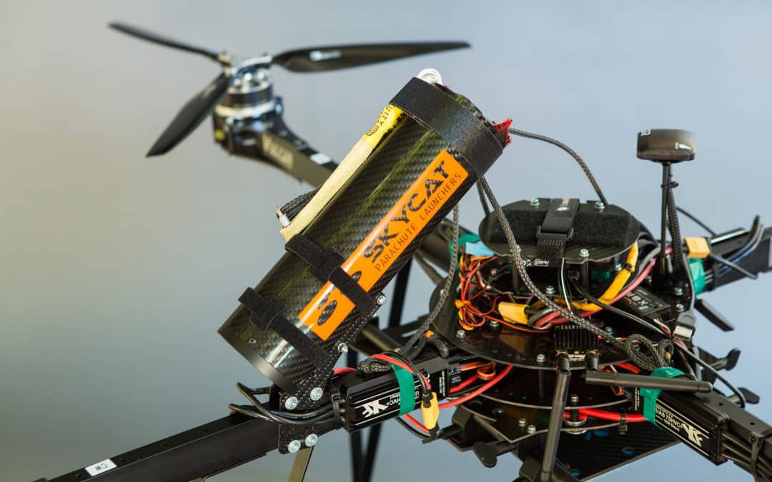
Multirotors have idled in regard to advancement. Good motors, precision GPS, and bigger more efficient batteries have allowed good flight times and safe operation. We use parachutes with our copters and feel comfortable sending them up.
Fixed-wing platforms are split into two distinct camps, hand and wheel launch. The small, quick wings cannot carry good cameras and data quality suffers. The larger platforms need wheels and smooth ground but offer the benefit of carrying a larger sensor for better images. There is crossover in these types including hand launch/belly or parachute landing; the blurred line is offering some possibilities.
I am hoping this next platform gets proven soon, I like where it is going. The VTOL (Vertical Take-off and Landing) plane holds promise. Lift like a copter then fly high and fast with a big camera for a long time. Like any other platform, power is always the issue, to remedy this, some makers are putting gas engines to be used as thrust motors and even generators. I think we will have something worthy by year-end.
Imaging
At this moment, the best solution for aerial topography is a full-frame sensor camera and a good lens. We can obtain good accuracy on a consistent basis. There are some improvements on the horizon that will help things.
When a drone flight is not possible due to regulatory restrictions, our trade partner Doug Andruik at Syn-Geo created a two-camera pod he puts on the strut of a Cessna and effectively does close-range photogrammetry with a full-scale aircraft. A great solution for large acreage or no drone zones.
We are all waiting until LIDAR becomes effective for use on a UAV. Several versions are out with fair accuracies and high price tags. Development is happening daily because of the great potential of the application. I’ll look at these and report as they become available.
Improving Accuracy
One of the best things to come along for improved close-range photogrammetry is precision GPS. The Applanix chips (Trimble) have made geo-referencing images more accurate and easier. When an image is correctly geo-tagged, post-processing is quicker and the resulting 3D information is more accurate. Combine this exacting geo-tagging and good images and accuracy get much better. This makes our fieldwork more efficient and the results in the office better. In my opinion, this is the go-to solution; for now.
Pix 4D is still the easiest post-processing software, my issue is the same data set run multiple times yields different results and residuals. As with any processing of imaging data, check to many ground control points to verify accuracy. UAS Master from Trimble is a robust application with the ability to fully incorporate precision GPS orientation from the Applanix chip. I use the software on a regular basis but am hesitant about training users. When you know how all the aspects of the program interface you can do some great things. When first learning post-processing, there are too many variables in the software to “just click a few icons” and get a result like in other applications. That Power can be a pain to use sometimes. Rumors are that there will be some easier workflows coming in future versions, I’ll keep you updated.
Contact TOPS for Accurate LIDAR and Photogrammetry Data
Right now the best way to get reliable, consistent data is to fly a full-frame mirrorless camera with a high-quality lens using a copter with an Applanix chip and post-process in the software of your choice.
Always collect a TON of control/checkpoints so you know how good the results actually are. We earn our money back in the office slowly going over data, cleaning up the point cloud modeling, and shipping the client a good surface.
Whether it’s for urban planning, environmental assessments, or infrastructure projects, TOPS photogrammetry services have proven to be an indispensable tool for professionals. Embracing such cutting-edge technologies ensures that we remain at the forefront of geospatial innovations, harnessing the best of what modern imaging can offer.