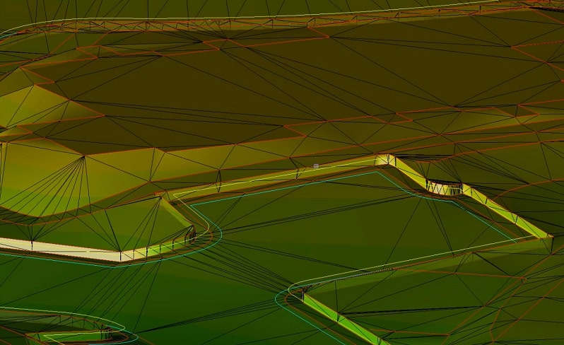
Our previous article on chasing perfection on civil sites covered the balance between a perfect model on screen and a well-priced practical job that performs well. In this article, we further explain the details that we touched on as well as additional tips to use to make a job run smoother.
If you take the approach of creating a ton of data for a jobsite, it takes too much time and will confuse a field user that may not be aware of the enhancements made to their job. Some of our clients have used the following ideas at one time or another but not all of them at once. Another consideration is phasing and machine type.
There are two important things to consider before deciding to use information above a basic model; the benefit of the data in the field and the cost to produce it. Also confirm the desire and ability of field crews to wisely spend that additional work and money. Regarding enhanced data, I can work with two different crews from the same company and get buy in from only one. Culture sometimes is not companywide. You need a champion to grab a new idea and leverage it for real success.
START AT THE BEGINNING
We need to establish a point of departure for my ideas. At the bare minimum, you should present to the field a correct finished surface model showing areas that are going to be worked with a blade. Nothing fancy, but a faithful representation of the intent of the job. I use the word intent with an explanation. It is the intention of all involved to have a good looking well performing site. If the plans don’t reflect it, you are the last line of sanity before something incorrect gets put in the ground.
This basic model is what most companies who do in-house data provide. Office staff are just too fractured to spend too much time on any one job. I know, I’ve been there. When field crews get comfortable with a basic model, they usually want more information to boost productivity.
We will increase data information with a new user as their comfort level increases. The real trick is providing what makes the most impact for boosting productivity.
ENHANCED DATA OPTIONS
I like to produce the most bang for our client’s buck, and the following concepts can get you there. I will go through these concepts in a video as well. A few minutes of screen time can say a lot.
LINEAR FEATURES
Lines can be either 2D or 3D. Adding the third dimension may work okay for some data collectors but not machines. A 2D line with a surface reference beneath it seems to work in most cases. This will save on data prep time. The exception to this would be for a curb alignment in a parking lot. The top of a curb is only six (6) inches wide; to the inside of the line the elevation drops quickly to the gutter. We will often provide a top back of curb elevation surface that’s three (3) feet wide so the elevation is easy to find.
LAYOUT ITEMS
This broad term represents anything you might usually stake but want to reference at any time.
Start with the building pad blowup lines and a surface to the extents. We often provide foundation footing trench information. This is usually bottom of footing with vertical steps and varying widths. Pad footing locations and grid layout lines help with larger projects.
I’ll cover utilities in a separate blog post. There’s too much to list here. As a useful improvement to have on a machine or data collector, utilities are high on the list. 2D water, gas, and electric go a long way in helping the field team plan their trenching. Sloped pipe utilities are best laid out in 3D for improved production. Structures are often a mix of 2D and 3D information. More on that in the video.
SUBGRADES
I often get into lively conversations regarding subgrades. There are only two choices when it comes to cutting a subgrade; provide a surface file or dial down. We usually try to provide just a finished surface file for several reasons:
Building additional surfaces cost money.
When you dial down in a machine and offset a subgrade behind the back of curb the machine does a better job than data prep software. Let me explain here and in the video. Parking lots have variable cross slopes, often changing quickly and greatly. A horizontal offset in a machine correctly projects the slope. It is not easy to do this properly in the office.
Many data collectors and machines show the vertical offset on the screen, so you know when you are off finished grade. We also like finished surface files because they match the plans. This makes it easier to check grades against the plans without the potential for bad math.
HARDSCAPE
With hardscape there are a lot more things you are either responsible for or can just help to move along. When it comes to hardscape items, GPS can help with grading and the initial ground setup. We will usually include layout items that are 2D but beneficial.
Streetlights: Parking lot lights can be laid out early so underground electrical can go in.
Parking Lots: We provide layout for parking lot striping and special marking. This helps the striping to move along quickly.
Playground Equipment: Layout is critical. Setting bases and foundations with technology is a time saver.
OFFSITES
Turn lanes are often built during a civil site improvement. When plans were prepared, the topo shows existing pavement elevations. Usually these are not correct as the topo is old or the lane was not shut down and the spots were estimated. Here is how we correct this:
The contractor will get quality spot elevations at 10 feet along the proposed saw cut line.
We bring the information into the model.
Proposed changes are made in the model and sent to the contractor for submittal.
Approved updates are sent to the field for work.
ENHANCED DATA ADVANCEMENTS
As we become more reliant on electronic data and placing dirt with technology, the idea of enhanced data might be considered standard by many. I will now go over some new and exciting offerings for data. Many of these suggestions are responses to questions that I’ve received. I appreciate the feedback and enjoy the interaction.
One of the biggest advancements we have enjoyed is the use and accessibility of drones and LIDAR. With an easier way to acquire current ground information, we now need to know the best way to work with it. Here are some tips and processes that will help.
The biggest issue we see with using alternate collection methods is platform compatibility. The LIDAR or drone shots do not match when compared in the office. Here is a process to try.
LIDAR
Use the same control for scanner setup as you did for localization. You will need to bring in control quality points to the site and set up the machine over them. Might be best for your surveyor to add the points.
When scanning, take some long occupation topo shots of the area being worked to compare at the office later
TBC has a command called Points to Surface. Use it to see how things look.
Usually there are greater vertical errors at the edges of scans, perform closer occupations to stop this.
Never do an adjustment of a scan or tweak the data vertically. Go out and do it again the right way.
Realize that sometimes LIDAR is not the tool and either use a drone or manually topo.
Drones
Control is critical here. Make sure ground targets are survey grade and reuse the same locations on each flight. You need to pick target areas that will not be greatly disturbed during construction.
Regarding light, flight time is important. Fly in the same sun angle every time, and as high as possible.
Process the data the same every time. If you send it out, this may be harder but set the same options for each flight.
Run the Points to Surface command in TBC. Carlson has the same type of command as well.
Look for areas that are not in tolerance. Do not adjust anything; just go fly again tomorrow.
These tools are now affordable and easier to use than ever. Your use of the surfaces created and enhanced data will improve efficiency and profitability.
From the ancient wonders of the world to the modern buildings we inhabit today, surveying technology has been helping us measure for thousands of years. We’ve come a long way from the rope stretchers of ancient Egypt, but land surveying technology is still evolving. Like every industry, the future of land surveying is set to change in the coming years. Between an increase in drone usage, improvements in mobile 3D mapping and changes in data management, surveying has many developments ahead of it. The trends have implications for the industry that can improve data collection, change data storage approaches and offer more accessible and flexible information gathering.
Today we’ll be going over what the future of land surveying technology looks like and what some of the top land surveying trends are shaping up to be.
Unmanned Aerial Vehicles (UAVs) in Surveying
Unmanned aerial vehicles (UAVs) have become more and more accessible and affordable, making them great additions to a surveyor’s arsenal. Before their widespread availability, they were often thought to be cost-prohibitive for many applications and were reserved for military use. Now, they offer several advantages over both terrestrial surveying teams and manned aircraft. Drones can:
Cover large surface areas in a short amount of time
Cross difficult terrain
Take detailed images of hard-to-reach landscapes
Accomplish land surveys, photogrammetry, 3D mapping, topographic surveying and more
Traditional methods often couldn’t complete these tasks, whether due to complex terrain or the sheer amount of time it would take with land-based approaches. Surveyors can now get their aerial data quickly and accurately with modern drones. UAVs also make the job safer, so human operators don’t need to fly over or enter hazardous environments to take measurements. Drones are becoming standard, less of a “bonus” and more of a necessary component of landscape businesses. Using them may soon become an industry standard.
Stay Current with Leaders in Surveying Technology
At TOPS, we actively stay up-to-date on the latest technology and industry trends in land surveying. With our fast, accurate quotes for 3D machine control models, and our dedication to advancements in the field, you can trust us to bring the future of surveying technology to your projects.
Expanding Drone Applications in Land Management and Development
Drones are also often used for cadastre, opening up a significant area of use. In addition, they can provide data that integrates with computer-aided design (CAD) software to build models for land development and management. Another benefit of drone usage is that it can provide a variety of photos for recording land data and structures.
Some other forms of data that you can collect from drones include:
2D Orthomosaic maps: Stitch together photos from a drone to create a top-down aerial view.
3D Orthomosaic maps: Stitch together images to compile a 3D birds-eye view of a space.
3D models: Create detailed models from powerful mapping software.
Thermal maps: Record and identify abnormal heat signatures in an area.
LiDAR point clouds: We’ll talk more about LiDAR in the next section, but drones can help you create a high-density point cloud for use with this system.
Multispectral maps: Data outside the visible light spectrum can offer a variety of uses, including missile detection and satellite imaging.
Building information modeling (BIM): Combine high-resolution 3D programmatic or laser models with pre-made BIM objects. This information can help to identify variations and respond accordingly.
When it comes to achieving the greatest possible accuracy, drones can use additional tools, like real-time kinematics (RTK) and post-processing kinematic (PPK) positioning. Both are positioning techniques that can improve the precision of the data using information from satellite-based systems.
Advancements in Mobile 3D Mapping Techniques
Mobile mapping systems can provide extremely detailed images in a short time. They are flexible and allow you to create 3D models from a wide variety of environments. Indoor, outdoor and underground areas can all be extensively detailed with mapping technology.
It is fairly straightforward to collect geospatial data and use software solutions for fast and simple mapping. Surveyors can create digital replicas without cumbersome equipment or the need to wait hours to see the results. Versatile equipment options, handheld devices and aerial recording make mobile 3D mapping a viable and effective approach for many land surveyors. Many of the sites a surveyor visits can be dangerous or difficult to access. While they could spend valuable time and money trying to get into the area on foot and use traditional terrestrial tools, a more efficient option would be to use a UAV. Plus, this method keeps them out of any treacherous terrain. Similarly, if a surveyor needs to make a model of an extensive area, they can attach their recording devices to a vehicle and move through the site this way, offering a less physically taxing job and a faster result. These methods require very little training and are easy for new users to operate.
Mobile 3D mapping is available without the use of GPS surveying and in durable, splash-proof products, offering additional flexibility. This kind of product can help you map out hard-to-reach places, whether they are dark, dank or dangerous, through several different methods. Tools are often made to be light and portable for ease of use.
One of the most notable benefits of this kind of mapping includes real-time, instant results. You can transform your data into 3D visuals quickly, reducing the time it takes to see results. 3D-mapping software also tends to offer robust organizational features, such as bundling data into projects and managing single uploads automatically. This organization can extend to mobile devices, including apps and third-party plugins. Some even provide features such as automated measurements, asset inventory workflows, face blurring and more to offer more of an all-in-one approach.
Enhancing Data Accessibility in Surveying
Another growing piece of technology is LiDAR, a form of 3D laser scanning. LiDAR stands for Light Detection and Ranging and uses a pulsed laser in ultraviolet, visible or near-infrared light to measure variable distances to the ground or nearby objects. The machine is composed of a laser, a special GPS receiver and a scanner, and they usually utilize airplanes and helicopters to gather their data across large areas. This remote sensing method collects information from the light pulses and other data collected from the aerial system to create detailed 3D models or gather survey information about the physical characteristics of the Earth.
Types of LiDAR Surveying Techniques
There are several different types of LiDAR, including:
Terrestrial: This type of LiDAR maps the Earth’s surface through topographical measurements that are mounted on the ground. Surveyors can map 3D-point clouds from the scanner with digital images to quickly make realistic 3D models. It can bypass the cumbersome tasks of measuring each item, like power lines, bridges, trees and more that may be in an area.
Bathymetric: Bathymetric LiDAR measures elevations of riverbeds and seafloors with the help of a green light that penetrates water and its reflection back to a sensor. The measurements are typically taken from the air.
Airborne: A laser scanner can be attached to an aircraft and used to create a 3D-point cloud model of a landscape. It is detailed and accurate, helping to create digital elevation models (DEM) and digital surface models (DSM).
Applications of LiDAR Surveying
This system provides a new level of precision and flexibility to the measurement of both organic and manmade structures. It may also pave the way for the automation of vehicles and assisting in lunar-landing vehicles. LiDAR is growing in use in a wide range of applications:
Agriculture: Topographical data from LiDAR can help identify patterns of sun exposure, insect behavior and features in the landscape to improve farming tactics.
Archaeology: Archaeologists use LiDAR technology to help plan field campaigns, map features under tree cover and create DEMs of archaeological sites for more detailed images. For instance, in 2013, it was used to rediscover the city of Mahendraparvata in the Cambodian mountains.
Atmosphere: LiDAR is used in meteorological applications to provide information on surface pressure, greenhouse gas emissions, fires and photosynthesis. It can measure backscatter from the atmosphere and reflections that scatter off a hard surface.
Physics and astronomy: LiDAR can help measure distances and the position of the moon and create topographic information about other planets.
Wind farms: LiDAR can measure wind speeds and turbulence to help optimize the performance of wind farms.
One of the major benefits of LiDAR is that it offers real-time point clouds. Not all systems have this option, but many do. This feature can provide significant advances in the way of speed and accessibility, making projects more flexible and efficient.
As LiDAR systems become less expensive and more accessible, they are likely to be more common in survey projects.
Outside of LiDAR, general data accessibility is likely to improve, as more advanced tools become more affordable. Products that were previously reserved for only the most prestigious of tasks, like those in the military, will become more commonplace and may even become industry standards.
The Role of Cloud Computing in Data Storage for Surveying
As scanning technologies have become more complicated and advanced, they have started to create more data. All of that data takes up valuable space and can quickly become a burden on the IT capabilities of land surveying organizations. Many of them don’t have the storage infrastructure to support such a growing amount of information in a physical, on-site data center. To remedy this, many companies are turning to cloud storage, in which data is kept off-site, in a secure location and managed by a third-party company. Often, these companies offer high levels of security with dedicated experts working around the clock to protect their clients’ data. Most importantly, it takes the burden of finding space for the data away from the survey companies. They can spend less time worrying about the security of their information and more time working on projects or investing in better equipment.
These survey organizations have to store data for thousands of projects, and they can repeatedly outgrow their capacity as they accumulate more projects and business. Cloud storage is scalable and allows land survey companies to leave the issue of storage capacity to their servicer. Storage infrastructure can be costly and time-consuming, so many organizations are aiming to offset these problems and let someone else manage their information. Similarly, processing power can also be scalable. Some point-cloud software uses significant amounts of processing power from an off-site cloud center to deliver high-demand results to the user. The option to beef up power when needed is often appealing to surveying companies.
Another reason that many companies are moving to cloud-based storage is for the ability to share and access data more easily. Cloud storage eliminates the need to send files, which is essentially copying and redownloading them, often resulting in duplicates or creating unnecessary data. As well as taking up extra space, this can lead to misinformation or outdated files. With cloud storage, users can instead access the same data, and they can do so from a variety of devices wherever they have a connection. In-field access is an excellent tool for surveyors, offering them the ability to upload scans and view data as needed while on-site.
Here are a few more reasons companies are moving to the cloud:
Manageable costs: Startup costs for extensive data storage can be high, but many cloud data servicers run off of subscription models. This approach can make the service more affordable and predictable for land surveying companies, but it would also be a monthly cost rather than a capital investment. Organizations will have to decide if that approach is right for them.
Reduced maintenance: Surveying companies don’t have to worry about updating or installing local software and may save on IT costs and time. Plus, they receive the help of dedicated digital storage professionals to keep an eye on things.
High power: Some organizations need to run robust programs to read and analyze their data, which may take ages on a local computer. Cloud-based software can offer higher-powered programs that may be able to get the job done quicker.
Automated scans: Some programs can automatically start registering scans into a composite point cloud as they are uploaded. This approach can speed up the process and even help surveyors access completed point cloud data from the worksite.
Collaboration: Many surveyors have to work with a variety of partners, including contractors, engineers and other stakeholders. Cloud services make sharing data with third parties much more straightforward than before. Surveyors, management, engineers, clients and more can share information quickly and with controlled permissions, improving collaboration between parties. Surveyors can ensure that only those who need access can view the data, as well.
Though cloud-based storage is a powerful tool, it can change the way organizations operate. For those using massive amounts of data, costs can add up. Surveying companies must crunch the numbers and analyze their unique needs to find out if cloud data is right for them.
Collaborating with Expert Data Modelers in Surveying
For your data modeling needs, Take-Off Professionals has been creating accurate 3D models for over 20 years. Whether you are a contractor or surveyor, we can provide fast and accurate quotes for 3D machine control models.
When you work with us, you work with industry experts. Our team of licensed engineers, surveyors and 3D technicians ensures that we stay up to date on the latest technology and industry trends in land surveying. Whether its the ease of use and versatility of UAVs, the flexibility of mobile mapping or the changes in data storage, you can be confident that our staff is up to date on these topics and whatever comes next for the future of land surveying and surveying technology.
With 3D technology, earthwork modelers and surveyors can view virtual models of proposed projects before the groundbreaking work commences. Different types of software can generate such visualizations, and this has led to the BIM vs. CAD modeling debate. Both options have their benefits and supporters.
For anyone new to these software tools, it’s important to be able to make an informed BIM and CAD comparison. Therefore, it is crucial to understand the pros and cons of BIM and, likewise, the pros and cons of CAD.
Make a Precision Decision with TOPS 3D Modelling
Get ahead in your construction initiative with TOPS. We employ a team of experts to develop 3D machine control models, ensuring a clearer, more precise vision for your project before construction commences. Using TOPS provides easy work order creation and thorough project visualization.
Building information modeling (BIM) is a set of software tools that make it possible to visualize a design idea with realistic dimensions from a multitude of angles. With BIM, design teams and work crews can have a virtual experience of a building, road, bridge or monument before the structure is physically constructed. For all the parties involved in the conceptualization and construction of a structure — including earthworks and surveying crews — BIM provides the following benefits and features:
Preventing Conflicts with BIM
BIM tools allow earthwork teams to determine whether any clashes might occur between a proposed design and the underlying conditions of the site in question. For example, if a building would need deep plumbing yet the ground being excavated sits over thick roots and rocks, these discoveries can be factored into the design plans to avoid issues down the line.
Reducing Errors Through BIM
BIM technology makes it possible to catch any errors that initially appeared in a proposed design before the construction work goes into effect. For example, if earthwork crews discover that the dimensions of a proposed building design will not be feasible at the prospective site, planning crews can take this information into account and either make adjustments or change the overall plan.
BIM in Construction: An Overview
BIM software is used by construction crews who break grounds on new lands to establish the foundations of roads, highways, buildings, bridges, monuments and structures. The software makes it possible to determine which structures will ultimately work over certain types of soil, thus making the processes involved with earthworks easier for planners and crews.
BIM for Ground Logistics Enhancement
BIM software contains a range of features that specifically outline the logistics of plumbing at a given work site. This way, planners can determine whether the stretch of land in question will be suited for the project at hand, be it a tall office building or a wide industrial facility.
Planning Piping with BIM
BIM solutions make it possible for earthworks crews to determine which type of piping will suit the stretch of land in question. The software can be used to create 3D piping designs that take into account the diameters and lengths necessary to transfer water underneath a proposed building site to the nearest reservoir.
Enhancing Collaboration with BIM Tools
BIM solutions offer collaborative tools that make it possible for earthworks teams to interact with other teams in the construction process, from designers and architects to builders, planners and investors. Collaboration tools include communication technology that works across different platforms, allowing cloud-based branches to interact with more traditional departments.
BIM and Visualization Technology
BIM tools make it possible to visualize a site in 3D and determine how a potential structure will appear from the ground up at a given site. Based on the position of the proposed structure, the tools allow earthworks and construction crews to determine how sunlight will hit the walls of the building or factory and potentially light its interiors.
Sequencing Steps with BIM
BIM software programs arrange the building process in a series of steps from the ground up, including the logistics involved for earthworks crews. The tools can be used to determine how wide the clearance will need to measure for a proposed structure and how deep the ground will need to be broken to support the height and plumbing needs of the building in question.
Exploring Advanced Features of BIM
BIM solutions go beyond 3D technology to make a full-scale planning sequence for earthworks and developers. In new and upcoming versions of the software, BIM is activating tools in 4D, 5D and 6D, giving users the ability to visualize cost logistics in tandem with design concerns. These more advanced features also make it possible for users to determine the thermal and acoustic properties of a proposed building on the site in question.
Addressing Potential Issues With BIM Software
On the downside, BIM has yet to be developed to the point of universal compatibility across all branches of the construction industry. Companies and crews that have fully embraced the technology may have problems communicating certain ideas, information and visuals with cooperating entities that still rely on older technology.
Due to the relative novel nature of BIM technology, expertise in BIM software is a relatively small field. Consequently, there are few technicians to consult when users need outside support on a given issue.
Exploring CAD (Computer-Aided Design)
Computer-aided design (CAD) is a set of software tools that allow designers to create 2D and 3D virtual models of buildings, structures, machines and parts. For surveyors and earthworks crews, CAD makes it possible to review a proposed structure before commencing work on the ground. The features as well as pros and cons of CAD can be summarized as follows:
Visualization Benefits of CAD
CAD software makes it possible for designers and project developers to visualize a product or part in advance of its production. The software can be used to examine a proposed design from a variety of angles, both inside and out. Whereas conventional designs offer a flat illustration of a proposed idea, CAD makes it possible to step inside of a design and view it from a 360-degree perspective.
CAD’s Role in Improving Communication
CAD allows developers to communicate about the logistics and dimensions of a given design and make improvements as discoveries come to light. For earthworks crews in need of new tools and machines for an upcoming set of tasks, CAD provides an easy way for designers to communicate with team supervisors.
The Application of CAD in Structural Engineering
CAD software accommodates the various aspects of structural engineering. Moreover, most CAD programs offer functionalities that apply to specific industries and the various branches that the projects entail. For projects that involve railroad, tunnel or freeway construction, the design features take all the dimensions into account as the design team drafts a 3D visual of the proposed structure, which earthworks teams can then examine and use to visualize the intended finished project.
CAD for Earthworks Logistics
When the design for a proposed building, road or bridge is created on a CAD platform, the visualizations that the technology provides make it easier for earthworks crews to foresee how the finished structure will look from the ground up. This knowledge can then be compared to the findings of work teams as they survey the land in question and prepare to break ground.
Ensuring Accurate Design with CAD
CAD platforms make it possible for civil engineers to generate maps and analyze specs across a stretch of land. This research enables better-informed designs for railways and tunnels, thus reducing potential errors and costly redrafts down the line. This information can then be communicated to earthworks crews, making the overall plan more efficient and easier to bring to fruition.
Facilitating Input and Feedback
CAD platforms allow conceptualists to take a raw idea and turn it into a three-dimensional design. This allows different branches of a development team to mutually review a proposed design idea and make suggestions that can easily be implemented. If an earthworks supervisor spots an issue with a proposed design, the design engineer can immediately take this feedback into account.
The Advantages of Advanced CAD Tools
CAD software comes equipped with various design tools that facilitate ease of use and also make it possible to achieve visualization effects that would not be possible with a flat illustration. For example, both 2D and 3D CAD software contains a gripping feature that allows designers to pull, alter, adjust and reshape the dimensions of a proposed structural concept. If an earthworks supervisor reports that a road or pavement design requires a width adjustment, a grip tool can help employees quickly make those changes.
Potential Challenges When Using CAD Software
CAD software typically takes time to master, meaning that the cost of training can be high and the learning curve can be long. Moreover, the number of CAD experts is relatively small, which can make it difficult to find help if a problem arises.
For any company that has yet to migrate to a cloud server, CAD would be a step removed from that company’s technical infrastructure. As with most new technology, CAD is primarily designed for companies that are up to date on today’s more advanced systems.
BIM vs. CAD: Highlighting the Differences
A quick rundown of the features of BIM and CAD makes the two seem rather similar. So how do you compare BIM and CAD? The two have some crucial differences that make each more suitable for different types of projects. So what is the difference between BIM and CAD?
The biggest difference between BIM and CAD is the interactivity of the different dimensions during the editing process. BIM has interconnected objects, so any change that needs to be made in a building design, such as the width of a wall or corridor, can be done in a single edit. CAD does not have interconnected objects, so edits must be made individually.
CAD was developed to design virtual models for everything from appliances and furnishings to automobiles and rolling stock. CAD software tools are used to create 3D visualizations of the surrounding bodies of vehicles and tools, as well as the smaller parts that comprise the motors and fans inside each machine.
CAD can be thought of as a computerized sketchbook in which designs are hashed out and ultimately refined in 2D and 3D renderings. Each line works independently of one another and can be adjusted or eliminated without affecting any of the surrounding or underlying lines in the design. Therefore, if the design for a parking lot or road requires an extra three feet on one side, you can adjust the line that represents that side to accommodate the change in dimensions.
Complex CAD designs consist of numerous sheets, each with separate lines that are overlaid in a virtual file. If a design needs to be adjusted, you must adjust all the layers affected by this change individually. If a design consists of many layers that must each be adjusted in tandem with the others, making revisions can be complicated. With CAD, there is no way to synchronize the layers into a single-action item for a multi-layer adjustment.
BIM was developed more exclusively for the virtual design and multi-dimensional visualization of proposed building ideas. As such, the tools are designed to digitally render the complex dimensions of all the parts that comprise the interior and exterior of a residence, factory or office building, including the walls, stairs, doors, windows, ceilings, plumbing, wiring, lighting and ventilation.
A major difference between BIM and CAD is the interactivity of the different dimensions during the editing process. In BIM, the dimensions that comprise an object are interconnected. Therefore, any adjustment that needs to be made in a building design, such as the width of a wall or corridor, can be done in a single edit.
In BIM, the dimensions of a given detail can be synchronized to all instances of the detail in question. For example, if the windows on a building are initially designed to be 3.5’x5’ and need to be adjusted to 4’x5’, you can change all the windows on the virtual building with a single adjustment.
Deciding Between BIM and CAD: What’s Right for You?
Earthwork modeling and surveying teams can use BIM software to determine the ground dimensions of a proposed structure. Surveying crews can take a proposed building design and determine whether the chosen piece of land is right for the project in question. Earthworks modelers can then use the software to design the depths and dimensions at which ground will need to be excavated to set the foundations and build the sub-levels or layers of the building, factory, road, parking lot or structure.
For earthwork modeling, BIM tools can facilitate a more efficient flow of tasks because the software is designed to edit complex dimensions in a few steps. When all the dimensions of a construction layout are taken into account, BIM offers a more complex set of dimensions from various angles in a virtual preview. This way, all the parties involved in the construction can review the measurements beforehand and make suggestions or edits in advance of the project’s starting date.
BIM software tools can be especially advantageous for earthwork modeling of designs that consist of multiple levels. For example, if a development team proposes a multi-level courtyard across an acre of land, BIM tools can be used to accurately render the dimensions of this idea. The surveying team can then review this virtual design and provide suggestions and feedback. Construction crews can then reference this final design when it comes time to break the ground for the courtyard.
Data Preparation and 3D Modeling by Take-Off Professionals
For complex site work, it’s crucial to have 3D models to preview before construction begins. Take-Off Professionals is staffed by a team of expert engineers who develop 3D machine control models for earthworks projects as well as perform construction material takeoffs. Regardless of the size and complexity of the project in question, we can prepare data the way you need it. Contact Take-off Professionals to learn more about our 3D modeling services.
As a professional involved in architecture, engineering and construction (AEC), you’re likely familiar with quantity takeoffs. The term has been around a long time in the building industry, and it reflects an important part of the planning process. Quantity takeoff requires a highly specialized skill set to do data management correctly.
This crucial step in a project’s early stage can make or break success. In fact, improper quantity takeoffs can underestimate or overestimate construction costs, causing inefficiency in the entire construction chain.
It can be detrimental to any job when required material amounts and realistic pricing values are overlooked or duplicated. The key to successful construction data collection is thoroughness and accuracy.
Defining Quantity Takeoff in the Building Industry
Explaining what a quantity takeoff is in construction is relatively straightforward. Quantity takeoffs (QTO) refers to the estimation of materials, resources, and labor needed to complete a construction project. You review the project plans and take off information about what physical materials the architect, engineer or draftsperson specifies to assemble the project.
Quantity takeoffs in construction have many other names, including:
Estimating takeoffs
Construction takeoffs
Earthwork takeoffs
Material takeoffs
Material estimating
Material counts
Quantity surveying
Regardless of what you call them, quantity takeoffs are material-specific. As a rule of thumb, quantity surveyors or takeoff specialists don’t account for other project needs like labor, overheads, permits, insurance, equipment or incidentals. They stick to isolating material requirements and transposing that information into cost-based estimates.
Secure Winning Bids with Accurate Material Takeoffs
With TOPS, access professional material takeoffs boosting your project efficiency and bidding accuracy. Whether you have small-scale or vast earthworks planning needs, we ensure the best material takeoffs possible, enhancing productivity and profitability.
Technology has changed the quantity takeoff method, and for larger construction companies, computerization has been invaluable. Today, advanced processes like Building Information Modeling (BIM) and Computer-Aided Design (CAD) significantly increase estimation accuracy. These tools help to solve the age-old problem of low productivity and excessive waste, as outlined in a commissioned report by the Economist Intelligence Unit. They simplify the construction takeoff process to save time and eliminate errors.
The Impact of Building Information Modeling (BIM) on Takeoffs
BIM is a set of 3D design and modeling software tools that help visualize construction designs from multiple angles. These software tools provide a virtual experience of a structure before physical construction to prevent conflicts between designs and site conditions. One of the most significant advantages BIM offers is increased collaboration, as it includes various tools that help teams interact throughout the construction process. BIM streamlines project design and communication for more accurate construction takeoffs.
The Role of Computer-Aided Design (CAD) in Quantity Takeoffs
CAD programs revolutionized the building industry by allowing companies to build their projects digitally before actually breaking ground. Structures are designed in a virtual environment as 2D drawings and 3D models, allowing teams to work out any bugs and then move forward with reduced-risk structures in the real environment.
CAD offers benefits such as:
Optimized designs: Operators can test designs in various real-world conditions to identify the one that best meets project specifications and budget requirements. They can use these 2D and 3D models to optimize material usage.
Improved quality: CAD allows for greater precision and attention to detail by providing comprehensive construction visualization. More accurate representations lead to more accurate quantity takeoffs that enhance the project’s overall quality.
Decreased time: Using CAD facilitates efficient workflows that save time on project design and takeoff estimations. Operators can make adjustments quickly and collaborate with other team members seamlessly for quicker project completion.
Exploring Various Quantity Takeoff Methods
While computerization has increased takeoff accuracy and speed, the human element in quality takeoff examples can’t be replaced. Digital takeoffs are still at the mercy of human operators and interpreters just as manual takeoffs are. Today, we still rely on two quantity takeoff methods — manual and digital.
Traditional Manual Material Takeoffs
This is the oldest and simplest material takeoff form. Manual material takeoffs involve the estimator taking physical plans or blueprints and carefully detailing every material type and quantity specified on the construction drawings. This is a time-consuming data management process and prone to human error. It’s the estimator’s knowledge of materials, experience in estimating and skill in taking off material quantities that ensures accuracy. With manual methods, there’s no substitute for attention to detail.
Advancements in Digital Material Takeoffs
Performing material takeoffs through computer analysis and database application is relatively new in the construction industry. The first effective CAD-based programs date back to the late ’80s and ’90s, and their sophistication quickly evolved to include computerized building models integrated with digital takeoffs. Digital takeoffs are superior to manual methods for large and complex projects because of their speed and thoroughness. The qualifier is the takeoff technician being properly trained and proficient with the software application as well as highly attentive to applying the takeoff information into cost-based results.
Quantity takeoffs can be complex and involved processes. However, they have a single purpose, and that’s accurate data management. Whether you employ manual takeoff personnel or equip them with the latest digital takeoff program, the outcome must be an accurate list of all materials required to complete the project. It also has to conclude with a meaningful price structure.
Key Stakeholders in Quantity Takeoff Processes
Everyone involved in organizing the front end of a building project needs to do quantity takeoffs. Material takeoffs aren’t a tail-end qualifier. They’re a critical step that begins the bidding process to propose a realistic contract based on accurate material and financial information.
No matter how small or large your project scales, you have to start by calculating how much it will cost and how much material it will need. That’s whether you’re looking at a single residential unit or a larger subdivision undertaking with compounded earthworks, utilities, road surfaces and integrated above-ground structures. It begins by taking off materials, understanding what you have to work with and predicting the eventual price.
Architects, engineers and construction managers aren’t the only people needing to do quantity takeoffs. No matter what industry you’re in, if you build anything at all, you’ll require material calculation and price estimates. Here’s a list of professionals who need to do material takeoffs:
Urban master planning and smart city designers
Tunneling and subway architects
Residential home builders and renovators
Rail and metro transportation engineers
Offshore and marine architects
Landscapers and landscape architects
Highway and road engineers
General contractors and construction managers
Energy and utility contractors
Civil, mechanical and structural engineers
Architects and all building designers
Conducting a quantity takeoff takes skill, patience and powers of observation. It also takes a lot of experience. Quantity surveying is a high skill and a vital component to support project proposals. In fact, material data estimation is such a critical part of construction that many managers retain specialized independent takeoff professionals to do quantity takeoffs for them.
Like every facet of infrastructure in building construction, quantity takeoffs are a process. Learning how to do a material takeoff is a skill people can potentially manage if they have the time and resources to train in their system and then allow field time to polish their skills.
Learning in the field can be expensive. Humans are prone to error and manual takeoffs are especially open to misinterpretation, omission and wrongful calculation. So are digital takeoffs if the source input is wrong or the program operator fails to apply sound principles.
There are two ends to ensuring quantity takeoffs are sound and therefore meaningful. Deviating from either path can result in mistakes that can compound errors. An input error is sure to create a wrong end-calculation, and a bad output mistake can have equally damaging effects on money, time and inefficiency.
Getting a quantity takeoff correct is a matter of following a proven process. This formula has been around for years, and it’s the same method whether you use manual or digital takeoff methods. These are the two parts of doing an accurate quantity takeoff:
The Initial Phase: Input Considerations
Proper material takeoffs begin with inputting accurate information into the plans. Whether your draftsperson still hand-draws blueprints or your CAD operator creates multi-layered, three-dimension building models, your takeoff technician is paramount to managing data. This starts by inputting precise information onto the blueprints or into the computer-assisted takeoff software.
Your takeoff personnel only have so much control over what they’re given. Normally, a designated estimator won’t prepare the original concepts, working drawings or CAD layouts. Others in the building chain usually design and specify projects. However, an astute takeoff tech can spot irregularities and account for them during their data management. This is a critical control in the input stage.
The Final Phase: Output Specifications
Performing material takeoffs is core to the data management output stage. Output turns concepts into physical entities, and this is where accurate material estimation is essential. Putting out hard figures from software printouts creates solid estimates, which are the foundation for successful bids.
Here is where your takeoff person or team has control. Setting aside errors and omissions, your material takeoff relies on a system of identifying materials, quantifying them and then attaching data to a price schedule. This systematic approach, if done right, results in a fair an accurate proposal to move the project forward.
Construction data management professionals take material takeoff output and put this information into schedules based on valid pricing structures. In small-scale projects, estimators might use values based on local suppliers or subcontractors. In large building proposals, estimators often use national pricing. Takeoff professionals know where to look for quality data to use in a quantity takeoff.
Criteria for Evaluating a Quantity Takeoff
For the most part, doing a quantity takeoff is a mathematical exercise. You extract or extrapolate material figures on the input side for the takeoff quantities in civil engineering. On the output end, you reference your material figures to values. This creates a base for a total project estimate which adds in additional costs for labor, equipment and overhead.
You’ll hear the term “quantity” used in material takeoff discussions. This is the name for identifying quantities of earthwork material being estimated. It might be the quantity of cut and fill required for earthworks. Or, it might be the quantity of pipe, steel or lumber necessary to complete a structure.
Quantity surveyors or material takeoff professionals have a special challenge. They have to turn two-dimensional plans into three-dimensional images to quantify them. Accurate quantity takeoffs come from both the two-dimensional and three-dimensional worlds.
With manual takeoff methods, the surveyor needs to think two and three-dimensionally and visualize the concept. Digital takeoff methods relieve a lot of this spatial load, but a technician still has to manage that data. Here are the base formulas takeoff professionals use to look for and quantify construction materials:
Unit count: This is the simplest takeoff task, yet it’s easy to miss something in a unit count. When planning a building, estimators will count single items such as light fixtures, pipe fittings or door knobs. They calculate the total unit figures and multiply by unit price to achieve a gross total.
Linear length: Total lengths or runs are specific to materials like lumber, steel and piping. These building products are difficult, or nearly impossible, to unitize. Estimators will add up the combined linear lengths of materials in this category and also add a gross value to it.
Surface area: Accurately estimating surface area materials is still a two-dimensional task. It doesn’t matter if it’s flatwork stones, floor coverings or roofing materials. The calculation is length times width, and this total gets quantified to a value.
Cubic volume: Here’s where the three-dimensional reality enters the material takeoff business. Earthworks, concrete pours and insulation are prime examples where you’d use a cubic volume takeoff. This is length times width times height, and it’s applied as a unitized number on a value column.
Physical weight: Calculating construction by weight often happens in addition to other takeoff quantification. You might hear pounds of steel or tons of backfill. Calculating physical weight is necessary when accounting for transportation costs.
Although material takeoff professionals pay strict attention to their two and three-dimensional calculations, they realize their figures eventually support two more construction dimensions. Time is an additional dimension on construction projects, as is cost. Because of time and cost, it’s vital to make sure material takeoffs are done right.
The Advantages of Precise Quantity Takeoffs
Quantity takeoffs have a significant effect on multiple project aspects, from initial design stages to project execution and construction. Ensuring precision in quantity takeoffs will set a project up for the greatest success. Accurate quantity takeoffs provide a detailed breakdown of needed materials, and by quantifying these needs, estimators can calculate costs that enhance project components such as:
Project estimation: Quantity takeoffs are the foundation of project estimations, so the more accurate the quantity takeoff is, the more accurate the project estimation will be. These estimates can determine whether a project is feasible within budget constraints and if it can be completed according to client needs and expectations.
Bidding: Accurate quantity takeoffs enable construction companies to place more competitive bids. With precise calculations for material quantities, companies can avoid overestimating or underestimating and demonstrate their efficiency and professionalism to win successful bids.
Budgeting: Budgeting precision is a result of accurate quantity takeoffs. Careful counting and calculations for material needs allow construction companies to estimate accurate expenses and deliver projects within budget.
As precise quantity takeoffs improve the accuracy of project estimations, bidding and budgeting, construction companies can:
Minimize material waste: Accurate quantity takeoffs determine the exact amount of materials needed for a project, helping to reduce overestimations. With accurate material needs, companies can optimize orders to reduce waste and increase profits.
Improve time management: Beginning a project with accurate quantity takeoffs can save time by reducing project delays arising from inadequate or incorrect material supplies. Precise quantity takeoffs also streamline project planning to speed up design stages and project execution.
Prevent costly rework: When quantity takeoffs are based on precise calculations, companies can ensure accuracy throughout the project’s duration to prevent expensive errors. Estimators can provide accurate, detailed information that prevents rework and promotes project success from the beginning.
Enhance collaboration: Clarifying material needs through accurate quantity takeoffs enables various teams to coordinate and communicate effectively throughout project design and construction. Clear project estimations promote transparent communication with clients, increasing their satisfaction and loyalty.
Perform cost tracking: Accurate quantity takeoffs enable effective cost tracking by yielding a clear picture of necessary, realistic expenses. They support informed decision-making by helping team members anticipate costs, reduce budget overruns and accommodate unexpected expenses.
Manage documentation: An accurate quantity takeoff serves as a valuable baseline for documentation and record-keeping. It provides a record of estimated quantities and costs that can be referenced throughout the project to assist with change management, progress evaluation and post-project analysis.
The Importance of Accuracy in Quantity Takeoffs
The United States construction industry generates huge costs and consumes massive time. American construction projects generate billions of dollars and employ millions of workers. Because of the money and people affected, it’s important to get material takeoffs right.
You have two main material takeoff options. The first is using the old and antiquated manual method. The other is using a modern and more accurate digital takeoff system. Your choice might depend upon how much time you have and what the cost of a digital takeoff system will run you.
Comparing time and cost against accuracy might be a tough data management decision. Fortunately, you have a third choice. This one makes a lot of sense when you’re under a time constraint and demand estimation accuracy.
It’s turning to a material takeoff professional to estimate for you. These experienced construction experts make sure your takeoffs are accurate, thorough and dependable. You can trust them to support your bids and your business.
Partner with Take-Off Professionals for Expert Assistance
We’re Take-Off Professionals (TOPS). We’re a team of experienced and knowledgeable engineers who will produce accurate data so you can manage your business and build your projects without construction estimation worry.
TOPS offers takeoff services to meet your individual needs. You might be a small-volume builder needing a simple material list to complement your proposal. Or, you might require a comprehensive plan for cutting, hauling and filling earthworks. Whatever your need, TOPs can help improve your productivity by ensuring you have the sharpest information based on the best material takeoffs possible.
Professional material takeoffs increase your bidding accuracy and work efficiency. This results in saved money and greater profits. For more information on how we can help with our quantity takeoff services, call the Take-Off Professionals today at 623-323-8441 or connect with us online.